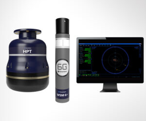
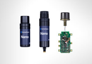
Showcase your capabilities
If you design, build or supply USBL Systems, create a profile to showcase your capabilities and connect with visitors who have an active requirement for your solutions.




USBL positioning systems provide acoustic tracking and positioning for underwater vehicles, divers, sensors, and other subsea assets operating beyond GNSS coverage. These systems use a compact transducer array to determine target range and direction, with surface navigation, heading, attitude, and motion data enabling georeferenced underwater positions.
This page features suppliers of USBL positioning systems for AUV and ROV tracking, mine countermeasures, diver supervision, subsea equipment deployment, and instrumented training ranges.
Read the Technology Overview
Undersea Sensing, Communications, Imaging, Control and Navigation Solutions for Naval Forces

Marine & Subsea Navigation, Positioning & Survey Technologies for Naval & Defense Applications

If you design, build or supply USBL Systems, create a profile to showcase your capabilities and connect with visitors who have an active requirement for your solutions.

Ultra-Short Baseline (USBL) positioning systems provide acoustic tracking and positioning for underwater vehicles, divers, sensors, and other subsea assets. A conventional USBL acoustic positioning system typically measures slant range from acoustic travel time and direction from phase or time differences across closely spaced transducer elements, allowing operators to determine a target’s position relative to a surface-mounted transceiver and the host vessel. Inverted USBL configurations can instead place the receiving array on the subsea platform.
For defense and naval operations, USBL positioning offers a practical way to maintain awareness of assets operating where Global Navigation Satellite System (GNSS) signals cannot penetrate. Modern USBL systems can combine acoustic measurements with GNSS, heading, attitude, and motion data to generate georeferenced underwater positions. A USBL positioning system may support Remotely Operated Vehicles (ROVs), Autonomous Underwater Vehicles (AUVs), divers, survey equipment, training targets, and deployable seabed systems.
Mine countermeasure missions can use USBL tracking to monitor Unmanned Underwater Vehicles (UUVs), ROVs, towed systems, and other underwater assets involved in detection, classification, identification, and disposal activities. Accurate relative positioning helps operators correlate vehicle or sensor locations with mapped seabed features while maintaining operational awareness.
USBL survey systems can provide position references for subsea sensors and vehicles conducting hydrographic, bathymetric, and infrastructure inspection tasks. They are particularly useful when positioning an ROV or AUV around ports, pipelines, cables, anchorages, and other underwater infrastructure where GNSS-derived surface positions must be transferred acoustically to a submerged asset.
A USBL tracking system can locate underwater vehicles and equipped divers relative to a surface ship or Unmanned Surface Vehicle (USV). ROV USBL and USBL AUV configurations are commonly used to maintain positional awareness during subsea missions, while diver USBL tracking can support supervision, coordination, and recovery during military diving and underwater engineering operations.
Naval forces can use USBL positioning to guide the deployment, relocation, inspection, and recovery of seabed equipment. A USBL beacon or transponder attached to a payload allows its position to be monitored during lowering and after deployment, helping crews place sensors, communications equipment, training devices, and other subsea assets at designated locations.
USBL underwater positioning systems can support instrumented ranges and training areas by tracking participating underwater assets. The technology can provide a common spatial reference for vehicles, targets, and other instrumented objects, supporting mission reconstruction and assessment of underwater movement.
A complete USBL system combines acoustic hardware with surface navigation sensors and processing software. The configuration depends on required range, platform, environment, and positioning accuracy.
Together, these elements allow an ultra-short baseline system to transform acoustic range and direction measurements into useful navigation and tracking information.
In a USBL vs LBL comparison, the most significant distinction is the acoustic baseline geometry. LBL normally uses multiple transponders separated across the seabed, creating long baselines from which a subsea vehicle can determine its position. It can provide highly repeatable positioning within a surveyed network but requires deployment, surveying, and management of the seabed transponders.
A Short Baseline (SBL) acoustic positioning system uses several hydrophones or transducers distributed across a vessel or structure. This physical separation creates a longer measurement baseline than the closely spaced elements inside a USBL transducer. SBL can provide effective relative positioning, but its installation generally requires more space and cabling across the host platform.
An INS estimates motion and position using inertial sensors without requiring continuous acoustic contact with a surface platform. Its position error can accumulate over time, so USBL navigation data may be used as an external position update. Combining inertial and acoustic USBL measurements can improve navigation continuity during intermittent acoustic tracking.
A Doppler Velocity Log (DVL) measures vehicle velocity relative to the seabed, or in some configurations relative to the water column, using acoustic Doppler measurements. It is commonly integrated with an INS for underwater navigation. USBL positioning provides a separate vessel-referenced or georeferenced position observation, depending on the surface navigation solution, that can help constrain accumulated navigation error.
Pressure-based depth sensors provide accurate information about vertical position but do not independently determine horizontal location. When integrated with USBL acoustic positioning, depth measurements can complement acoustic range and bearing data and contribute to a more complete estimate of a vehicle or subsea asset’s position.
Acoustic modems primarily exchange data through the water rather than providing a complete positioning solution. However, communications and positioning functions can be integrated within compatible subsea architectures. USBL communication links with integrated modem capability may therefore support command, telemetry, status reporting, or navigation data exchange alongside acoustic tracking when the equipment is designed for these functions.
The standards relevant to a USBL positioning system depend on its platform, mission, procurement program, and installation environment. Not every standard applies to every USBL system, so qualification requirements should be established against the intended operational profile.
Qualification should therefore be treated as a platform and program-level requirement rather than assumed from the basic capabilities of the USBL acoustic system.
Selecting an ultra-short baseline acoustic positioning system requires matching its acoustic performance, installation requirements, and navigation interfaces to the mission rather than considering range or headline accuracy in isolation.
A well-integrated USBL positioning system should ultimately be selected as part of the wider navigation architecture, with acoustic performance, host-platform sensors, calibration, environmental conditions, and mission requirements considered together.


 Searching Companies & Products


 Subscribe to the Weekly eBrief
The latest engineering and technical developments straight to your inbox - join thousands of engineers who receive it.
Subscribe to the Weekly eBrief
The latest engineering and technical developments straight to your inbox - join thousands of engineers who receive it.