If you design, build or supply Underwater Positioning, create a profile to showcase your capabilities and connect with visitors who have an active requirement for your solutions.
Suppliers: Underwater Positioning
Undersea Sensing, Communications, Imaging, Control and Navigation Solutions for Naval Forces
Marine & Subsea Navigation, Positioning & Survey Technologies for Naval & Defense Applications
Products
Underwater Positioning Systems for Military Navigation and Asset Tracking
In this guide
- Applications Across Navigation and Asset Tracking
- Technologies Used in Subsea Positioning and Tracking
- Navigation and Tracking Integration
- Comparison of System Functions
- Standards for Defense and Subsea Use
- Tracking Assets in Challenging Environments
- Use in Strategic and Tactical Missions
- Component Overview for Navigation and Tracking Systems
- Operational Considerations
Underwater positioning systems deliver reliable and accurate location data to support military navigation and the tracking of critical subsea assets. In operations where GPS cannot penetrate, these systems provide the situational awareness necessary for controlling underwater vehicles, monitoring assets, and conducting missions in complex or contested maritime domains.
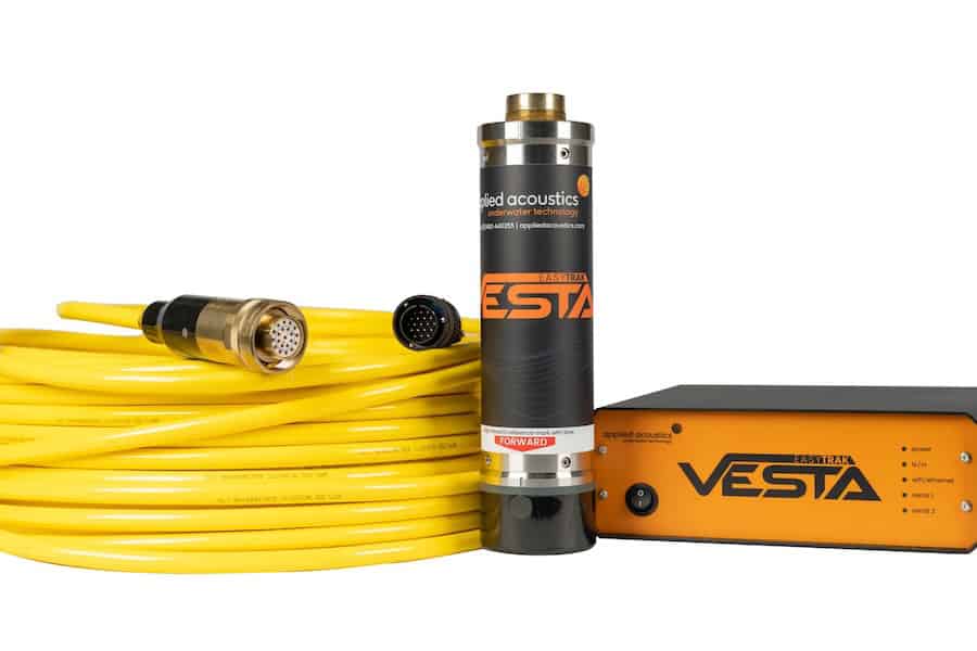
Technologies such as ultra-short baseline (USBL) acoustic positioning, inertial navigation systems (INS), and Doppler-based systems are integrated into military and commercial platforms to enable consistent navigation and persistent asset visibility. These systems are crucial not only for guiding vehicles but also for managing distributed equipment and resources across the seabed and water column.
Applications Across Navigation and Asset Tracking
Underwater positioning systems serve a dual role in military and defense environments:
- Military Navigation: Enables strategic routing for submarines, autonomous underwater vehicles (AUVs), and remotely operated vehicles (ROVs) using hybrid navigation systems that combine acoustic, inertial, and Doppler inputs.
- Asset Tracking: Ensures real-time monitoring of mobile and stationary subsea assets, including deployed sensors, diver teams, inspection platforms, and critical underwater infrastructure.
- Subsea Operations Coordination: Allows operators to track multiple vehicles and tools operating simultaneously, supporting mission synchronization and minimizing spatial conflicts.
- Search and Recovery Missions: Supports precise tracking and retrieval of underwater munitions, black boxes, or sensitive materials in post-incident scenarios.
- Infrastructure Security and Monitoring: Tracks inspection and maintenance equipment across pipelines, cables, and offshore structures to ensure continuity of operations and physical asset integrity.
Technologies Used in Subsea Positioning and Tracking
Systems typically combine multiple technologies to optimize both navigation and tracking functions:
- Ultra-Short Baseline (USBL): Triangulates the position of tracked objects using acoustic signals. Common for ROV/AUV tracking and diver monitoring.
- Short and Long Baseline (SBL, LBL): Uses arrays of seabed transponders for precise position referencing over broad areas. Ideal for static asset tracking and deepwater operations.
- Inertial Navigation Systems (INS): Provides drift-prone but high-frequency navigation updates, augmented by external corrections from DVL or acoustic fixes.
- Doppler Velocity Logs (DVL): Tracks velocity relative to the seabed, critical for position estimation in moving platforms.
- Transponders and Locator Beacons: Fixed or mobile devices emitting identifiable signals to mark asset locations or guide vehicle navigation.
- Acoustic Modems: Transmit and receive tracking data in real time, supporting two-way communications with submerged assets.
Navigation and Tracking Integration
Modern systems fuse data from multiple sensors to enable accurate navigation and robust asset tracking. This includes inputs from:
- Hydrophones and Transducers: Receive and convert acoustic signals for range and bearing estimation.
- IMUs and Gyroscopes: Provide orientation and movement data.
- Pressure Sensors: Supply depth and vertical positioning information.
- Kalman Filters and Data Fusion Algorithms: Combine inputs to reduce uncertainty and compensate for sensor drift.
By integrating navigation and tracking into a single operating picture, mission commanders can maintain high-fidelity visibility over both vehicles and fielded equipment.
Comparison of System Functions
| Function | Best Technologies | Key Capabilities | Use Case |
| Navigation | INS, DVL, USBL | Position estimation, heading, depth | AUV guidance, ROV control |
| Asset Tracking | USBL, LBL, Beacons | Real-time location monitoring | Infrastructure inspections, diver tracking |
| Hybrid Operations | INS + USBL + DVL | Seamless navigation and tracking | Coordinated multi-asset missions |
Standards for Defense and Subsea Use
To ensure system interoperability and ruggedness, underwater positioning technologies conform to established standards:
- MIL-STD-810: Environmental durability testing for defense-grade components.
- STANAG 4586: NATO interoperability framework for UUV systems.
- NMEA 0183/2000: Communication protocols for navigational data exchange.
- ISO 13628: Standards for subsea production systems and remotely operated tool compatibility.
Tracking Assets in Challenging Environments
Tracking subsea assets in real time poses challenges related to signal propagation, multipath effects, and environmental noise. Solutions include:
- Acoustic Beacons with Unique IDs: Ensure differentiation between tracked objects.
- Directional Transducers and Antennas: Improve angular resolution and reduce crosstalk.
- Low-Frequency Signaling: Enhances signal range in turbid or deep waters.
- AI-Based Signal Processing: Helps distinguish between legitimate signals and noise in high-traffic areas.
Use in Strategic and Tactical Missions
Underwater positioning systems that combine navigation and asset tracking are deployed in several mission-critical roles:
- Naval Logistics and Maintenance: Track supply pods and maintenance drones during submerged operations.
- Explosive Ordnance Disposal (EOD): Maintain visibility on diver teams and EOD tools in mine countermeasure missions.
- Multi-Asset Coordination: Track swarms of AUVs or ROVs conducting synchronized mapping, surveillance, or repair operations.
- Covert Surveillance: Track passive underwater sensors and surveillance assets without surface exposure.
- Rapid Recovery Operations: Enable rapid localization and retrieval of high-value items lost at sea.
Component Overview for Navigation and Tracking Systems
Key system components include:
- Hydrophones: Receive acoustic signals from transponders.
- Transponders/Beacons: Mark the position of assets or serve as navigation aids.
- Signal Processors: Compute position estimates from incoming data.
- IMUs: Provide inertial measurements for motion tracking.
- Compass Modules and Gyrocompasses: Offer orientation data to support navigation.
- Acoustic Modems: Relay tracking data between submerged assets and control centers.
Operational Considerations
Successful deployment of underwater positioning systems depends on:
- Mission Depth and Duration: Deeper and longer missions require more robust and power-efficient systems.
- Asset Mobility: Tracking requirements differ for mobile AUVs versus static infrastructure.
- Environmental Factors: Temperature, salinity, and bathymetry influence signal quality.
- Stealth Requirements: Systems must balance signal strength and detectability in sensitive operations.


