Image processing software converts raw defense sensor imagery into enhanced, stabilized, and analyzable intelligence for operational decision-making across air, land, naval, subsea, and space domains. It enables noise reduction, contrast optimization, image registration, georeferencing, object detection, target tracking, change detection, and multi-sensor fusion.
This page showcases leading providers of military image processing tools, designed for operation onboard UAVs, vehicles, vessels, ground stations, or within secure cloud environments.
If you design, build or supply Image Processing Software, create a profile to showcase your capabilities and connect with visitors who have an active requirement for your solutions.
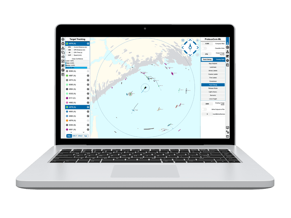
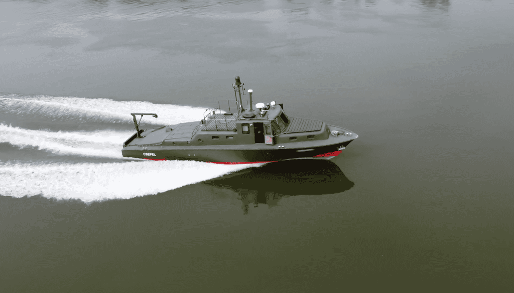
Machine learning-powered radar processing software for enhanced vessel perception
Machine learning-powered radar processing software for enhanced vessel perception
... is a powerful software package that utilizes proprietary machine learning models to provide rapid... ...he ProteusCore software automatically tunes radar gain and adjusts the range, continually optimizing...
Real-time video enhancement, tracking and optimization software suite
Real-time video enhancement, tracking and optimization software suite
...’s Video ProcessingSoftware provides a powerful and constantly growing suite of capabilities... ...using advanced image analysis and motion estimation, and persistent tracking is possible even when...
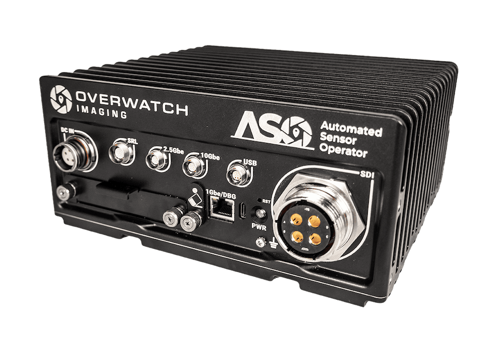
...sionmaking. By processing and analyzing imagery at the edge, ASO reduces bandwidth demands while... ......n search, while software-defined capability supports ongoing updates without hardware...
Overview of Image Processing Software for Military & Defense Applications
Overview by
William Mackenzie
Updated:
Introduction to Military Image Processing Software
Image processing software serves as the vital analytical layer that transforms raw sensor imagery into actionable operational intelligence. Within modern defense systems, these platforms enhance, stabilize, interpret, compress, fuse, and distribute data from sensors operating across air, land, naval, subsea, and space environments. Whether running inside an airborne payload computer, a vehicle mission computer, or a secure ground exploitation facility, these tools bridge the gap between raw data collection and split-second tactical decisions.
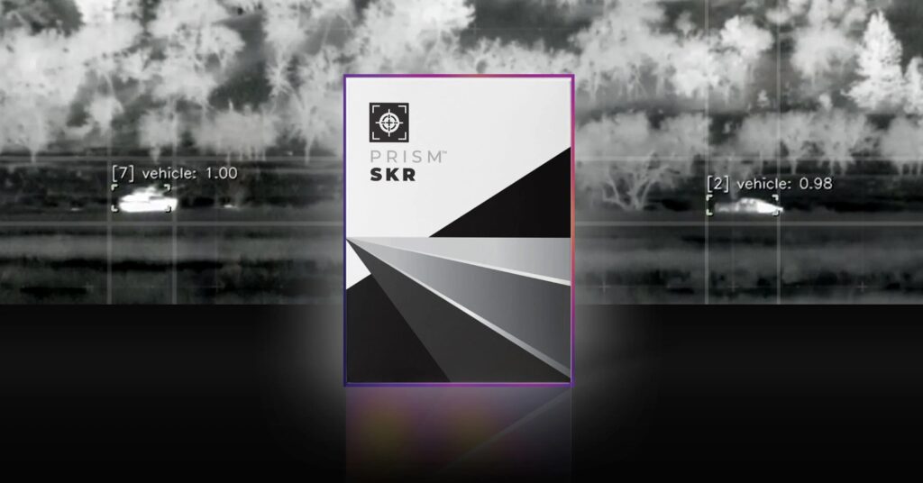
Prism ISP by Teledyne FLIR OEM
A sensor captures data, but raw imagery is rarely sufficient on its own due to platform motion, atmospheric turbulence, low contrast, and electronic noise. A comprehensive image processing solution enhances, aligns, filters, and analyzes imagery so that relevant features can be extracted more reliably. By correcting motion blur, atmospheric distortion, low contrast, and sensor noise, the software helps operators and automated systems identify terrain, infrastructure, personnel, and vehicles with greater confidence.
Core Functions of Image Processing Software for Defense Operations
Image Enhancement and Restoration
Image enhancement improves the analytical value of data by making vital features easier to isolate and classify. In tactical environments, this requires maximizing contrast in low-light electro-optical imagery, clarifying thermal signatures, and correcting for atmospheric haze.
Restoration algorithms go a step further by mathematically reversing known forms of degradation. For instance, imagery collected from an airborne platform often suffers from blur caused by high-frequency vibration or aerodynamic effects. Specialized image processing software utilizes precision models of these distortions to recover a clean image. This reduces ambiguity and directly accelerates downstream functions such as target identification while minimizing artifacts.
Noise Reduction and Contrast Optimization
Sensors frequently operate at the limits of their physical capabilities, resulting in high noise levels due to long-range observation, poor weather, or electronic countermeasures. Unchecked noise obscures small targets and triggers false alarms in automated systems.
Advanced infrared image enhancement and denoising pipelines target random speckling, grain, and thermal interference without stripping away critical high-frequency edges. Sharpening and contrast optimization then isolate boundaries, textures, and structural shapes. This allows operators to distinguish a military vehicle from rough terrain or a small watercraft from heavy wave clutter.
Stabilization for High-Vibration Environments
Sensors mounted on drones, armored vehicles, and naval vessels experience constant, unpredictable motion. While mechanical gimbals handle coarse stabilization, high-frequency jitter and rapid attitude changes require digital correction.
ProteusCore by Tocaro Blue
Software-based stabilization delivers a smooth video feed that mitigates operator fatigue and ensures consistent tracking performance. For live operations, this stabilization tool must function with ultra-low latency. Delayed video feeds compromise navigation, payload control, and threat awareness, which is why military-grade software is optimized for deterministic performance on ruggedized hardware.
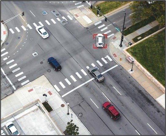
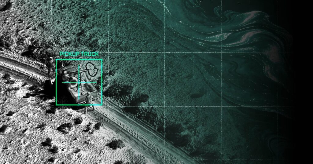
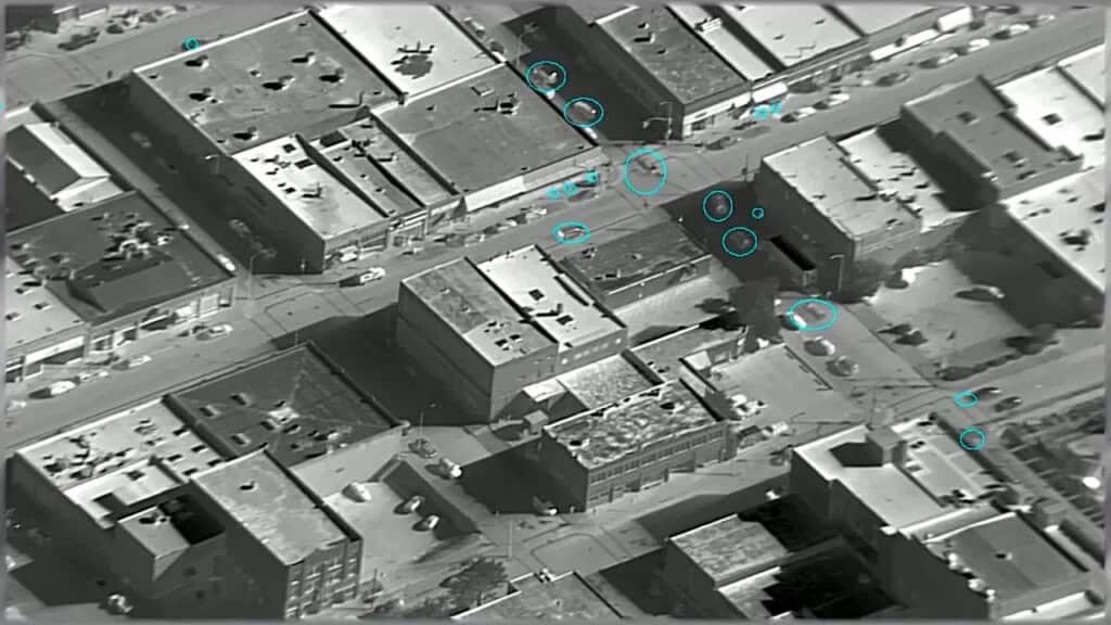
Object Detection and Automatic Target Recognition
The process of turning unstructured pixels into classified objects of interest relies heavily on automatic target recognition. ATR software scans a scene to isolate areas of interest, determine if they match known asset profiles, and categorize them into specific classes such as armored vehicles, vessels, or personnel.
While modern artificial intelligence drives this field, traditional computer vision techniques remain indispensable. Shape analysis, thermal contrast, and motion cues are blended to create highly robust detection pipelines. The most effective deployments combine automated classification with confidence scoring, allowing human analysts to focus their attention on high-priority targets.
Target Tracking and Motion Analysis
Once an anomaly is detected, specialized target tracking software estimates its velocity, heading, and future position across consecutive frames. This provides commanders with an understanding of intent, showing whether a target is approaching, loitering, or maneuvering evasively.
Reliable tracking is technically challenging because targets frequently pass behind structures, move through heavy clutter, or transition between different sensor fields of view. Modern software solutions handle these brief interruptions smoothly, maintaining track integrity and feeding clean coordinate data directly into command and control systems.
Change Detection and Activity Monitoring
Change detection software automates the process of comparing historic and current imagery to isolate changes in an environment. This is a foundational asset for route clearance, infrastructure monitoring, and battle damage assessment.
By automatically cross-referencing satellite or airborne imagery, the software flags new tracks in the mud, displaced objects along a supply route, or recent structural damage. Activity monitoring extends this into live video streams, tracking movement patterns and identifying abnormal behaviors or dwell times that require immediate human review.
Image Registration, Georeferencing, and Orthomosaics
Image Registration: This process spatially aligns multiple images taken at different times or by different sensors, establishing a precise baseline for comparative analysis.
Georeferencing: By anchoring pixels to real-world coordinates, georeferencing allows observed objects to be placed accurately on digital maps. The software links imagery to coordinates by cross-referencing platform telemetry, inertial sensors, and digital elevation models.
Orthomosaic Generation: High-performance drone image processing software stitches hundreds of overlapping aerial photos into a single, geometrically corrected map product. This provides a measurable, high-resolution view of an area for mission planning and post-strike analysis.
Compression and Bandwidth Optimization
Tactical networks often operate under severe bandwidth constraints, yet full motion video software and high-resolution sensors generate vast amounts of data. Image processing solutions solve this by utilizing adaptive compression and region-of-interest encoding. This technique preserves maximum fidelity for critical target pixels while aggressively compressing static backgrounds, ensuring vital data flows over restricted networks without introducing latency.
Specialized Processing Software Types
Modern defense systems deploy a complex array of imaging technologies. The table below details how specialized software variants optimize these diverse data streams for military operations.
Software Type
Core Technical Capabilities
Defense Applications
Hyperspectral and Multispectral Image Processing Software
Processes numerous narrow spectral bands to identify distinct chemical, moisture, or material signatures.
Assists in exposing camouflaged military assets, decoy materials, and recently disturbed tactical soil structures.
Radar Image Processing and SAR
Converts raw radio wave returns into readable imagery and models surface reflectivity values.
Delivers all-weather, day-and-night reconnaissance through thick cloud cover, rain, or total darkness.
Coherent Change Detection Software
Evaluates microscopic variances in surface texture and phase returns between successive radar passes.
Detects subtle surface disturbances, vehicle tracks, and indicators of recent digging or movement.
3D Image Processing Software
Filters, segments, and converts dense spatial datasets into accurate, navigable geometric matrices.
Processes laser range data to generate digital elevation models and slope estimates.
Evaluates safe helicopter landing zones, plans tactical approach routes, and builds synthetic training spaces.
Full Motion Video Software
Indexes continuous video streams while embedding synchronized, MISB-compliant metadata.
Transforms sprawling airborne reconnaissance feeds into a searchable, geo-tagged intelligence database.
Deployment Models Across Defense Networks
Selecting the correct architecture ensures that processed imagery reaches tactical decision-makers before losing operational value. Defense engineers rely on several distinct deployment strategies depending on platform constraints and network availability.
Onboard Platform Processing at the Edge: Software analyzes data directly within payload computers. This edge capability is crucial for UAV image processing software when data links are jammed, allowing autonomous navigation and lightweight metadata transmission instead of heavy video.
Ground Station Processing: Downlinked data streams enter localized workstations with expanded computational power. Here, processing software manages secondary exploitation, cross-mission comparison, and deep historical archiving.
Distributed Tactical Network Processing: Computational workloads balance dynamically across multiple active network nodes. Forward sensors execute initial edge detection, vehicle computers correlate tracks, and command nodes fuse the combined inputs.
Cloud and Private Defense Cloud Processing: Massive datasets are ingested within secure, air-gapped military cloud environments. Deployed at this level, heavy geoint software trains models and automates regional satellite image processing.
Ultimately, these models complement one another, creating a tiered architecture that balances immediate edge survival with deep, centralized theater analytics.
Emerging Trends in Military Image Processing
Driven by the need for faster execution cycles in contested environments, the technical landscape is evolving rapidly beyond static processing pipelines. These upcoming architectures focus heavily on localized machine intelligence, automated sensor workflows, and cross-domain synthesis.
AI-Enabled ISR at the Tactical Edge: Power-efficient neural accelerators run algorithms directly at the sensor source. This architecture filters out irrelevant imagery instantly, transmitting compact target metadata rather than continuous high-bandwidth video streams.
Autonomous Sensor Tasking and Adaptive Perception: Image processing platforms act as active closed-loop controllers. If tracking confidence drops, the software automatically tasks the sensor gimbal to adjust its zoom or switch spectra until identification parameters are satisfied.
Real-Time Multi-Domain Image Fusion: Systems concurrently align highly heterogeneous intelligence feeds. Advanced software suites synchronize live radar change detection with 3D terrain models and thermal video streams to eliminate sensor blind spots.
Coalition Interoperability and Secure Data Sharing: Processing pipelines utilize rigid metadata parsing engines to comply with strict international standards. This software facilitates real-time redaction, stripping platform telemetry while securely sharing target tracks across diverse allied networks.
As these software capabilities mature, they will continue to shift the operational burden away from manual human monitoring toward automated, high-confidence target validation.
Tocaro Blue has released ApolloCore™, a software solution that enhances marine PTZ cameras with perception, detection, tracking, and ranging capabilities for autonomous and defense vessels
Teledyne FLIR OEM has upgraded its Prism SKR software into a closed-loop autonomy platform enabling perception-based automatic target recognition and fully autonomous mission execution for guided weapon systems
Sightline Intelligence has launched Software Release 3.10.2, updating its ISR, video processing, and AI capabilities with expanded Aided Target Recognition, AI-assisted tracking, and improved metadata and geolocation support
Version 3.7.2 of SightLine Applications’ video processing software adds dual channel processing to the 1750-OEM, improves tracking and detection, and marks the release of the 4100-OEM dual processor
Medirlab’s Jumbo Marine multispectral camera system is expanding its low-visibility operational capabilities by integrating Thexovision’s real-time video enhancement software
May 08, 2024
Advancing Defense Capability Through Strategic Collaboration
Defense Advancement works with major OEMs to foster collaboration and increase engagement with SMEs, to accelerate innovation and drive defense capabilities forward.