Laser Velocity Sensors (LVS) are optical navigation sensors that measure vehicle velocity relative to terrain or another stationary surface, commonly using laser Doppler velocimetry. In defense navigation systems, LVS measurements can provide independent velocity updates to aid an INS, constrain inertial drift, and support dead reckoning when GNSS is unavailable or unreliable.
This page covers laser velocity sensors and laser Doppler velocimeters for aircraft, rotorcraft, UAVs, ground vehicles, and autonomous platforms.
If you design, build or supply Laser Velocity Sensors (LVS), create a profile to showcase your capabilities and connect with visitors who have an active requirement for your solutions.
Laser velocity sensing for assured navigation in GNSS-denied operations
Laser velocity sensing for assured navigation in GNSS-denied operations
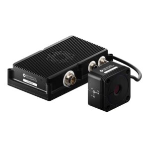
... a non-contact LaserVelocitySensor(LVS) designed to deliver uncompromised dead reckoning... Infrared laser Doppler sensing enables precise measurement of full 3D vehicle motion, capturing...
Precision navigation for military and commercial vehicles in GNSS-denied & contested environments
Precision navigation for military and commercial vehicles in GNSS-denied & contested environments
...ly accurate 3D velocity, attitude, and position data in highly challenging and contested... ...rface-relative velocity with the utmost in precision and sub-millisecond timing. It also achieves an...
Overview of Laser Velocity Sensors (LVS) for Military Navigation & Guidance
Overview by
William Mackenzie
Updated:
Introduction to Laser Velocity Sensors
A Laser Velocity Sensor (LVS) is a navigation sensor that uses optical measurements to determine the velocity of a vehicle relative to the ground or another stationary surface. Many systems apply laser Doppler velocimetry, measuring the frequency shift of reflected or backscattered laser light to calculate relative motion without relying on mechanical contact with the surface.
For defense navigation, this form of velocity sensing is particularly useful as an aid to an Inertial Navigation System (INS). A laser Doppler velocity sensor can supply regular velocity observations to a navigation filter, helping constrain errors that accumulate when an INS operates without reliable satellite positioning.
Core Functions of Laser Velocity Sensors for Navigation
Ground-Relative Velocity Measurement
A laser velocimeter determines motion relative to the surface observed by its optical beams. Unlike airspeed sensors, which measure movement relative to an air mass, ground-referenced laser velocity sensing can provide information about the platform’s movement relative to the terrain. This distinction is important for accurate dead reckoning and vehicle motion estimation.
Inertial Navigation System Aiding
An INS calculates movement using measurements from accelerometers and gyroscopes, but small inertial sensor errors accumulate over time. A laser velocity sensor can provide an independent velocity update that the navigation filter uses to constrain these errors and, depending on the system architecture, improve estimates of other navigation states. The result is a complementary architecture in which the INS supplies continuous navigation while the LVS provides external motion observations.
GNSS-Denied Navigation
Laser Doppler velocimetry does not depend on receiving satellite navigation signals. A laser Doppler velocimeter can therefore continue supplying velocity measurements when GNSS is unavailable, jammed, or otherwise unreliable, provided that the sensor maintains a usable optical return from the ground or another stationary surface. This makes LVS technology relevant to resilient navigation architectures.
Dead Reckoning and Drift Reduction
Dead reckoning estimates a platform’s changing position from its previous position and measured motion. An unaided inertial system gradually develops velocity and position errors, whereas regular velocity observations can help constrain that growth. An LVS does not normally provide absolute geographic position, but accurate ground-relative velocity measurements can improve the quality of the resulting dead-reckoning solution.
Velocity Updates for Integrated Navigation Systems
Modern navigation systems commonly combine measurements from several complementary sensors. Laser Doppler velocimeters can provide velocity updates alongside data from inertial sensors, GNSS receivers, radar, cameras, wheel encoders, or other aiding sources. The navigation filter can then evaluate available measurements and estimate the platform’s current motion and navigation state.
Position and Navigation Error Reduction
Velocity error eventually produces position error because an incorrect velocity estimate is integrated over time. By correcting or constraining velocity within an INS, a laser velocity sensor can reduce the rate at which position errors develop. Overall performance still depends on INS quality, sensor alignment, timing, navigation algorithms, vehicle dynamics, and the availability and accuracy of valid optical measurements.
Military Applications of Laser Velocity Sensors
Low-Altitude Aircraft Navigation
Low-flying military aircraft can use ground-relative velocity measurements as an additional navigation input when the terrain remains within the sensor’s operating range. A laser Doppler velocity sensor can complement an airborne INS without relying on wheel contact or satellite signals, although installation geometry, altitude, attitude, atmospheric conditions, and surface returns influence measurement availability.
Helicopter and Rotorcraft Navigation
Rotorcraft operate across flight regimes that include forward flight, low-speed maneuvering, hovering, and landing. Ground-relative velocity information can support navigation during these transitions, particularly when conventional satellite aiding is disrupted. Integration must account for platform vibration, changing attitude, mounting position, rotor-related interference, and the sensor’s optical line of sight.
UAV and Autonomous Aircraft Navigation
Unmanned Aerial Vehicles (UAVs) require reliable state estimates for guidance and flight control. An LVS can contribute independent velocity observations to the navigation stack, supporting autonomous operation when GNSS information is intermittent or unavailable. The sensor is typically used as one part of a multi-sensor architecture rather than as a complete standalone positioning solution.
Ground Vehicle Navigation
Wheeled and tracked military vehicles can use laser velocity sensing to measure movement relative to the terrain without deriving speed solely from wheel or track rotation. This can be valuable where wheel slip, track slip, tire deformation, or changing ground conditions reduce the reliability of conventional odometry.
Autonomous and Robotic Vehicle Navigation
Unmanned ground vehicles depend on accurate motion estimation for path following, localization, and autonomy. A laser velocity sensor can provide an additional velocity reference that is independent of wheel encoders and GNSS. Fusing this information with an INS, perception sensors, and other navigation aids can improve continuity across changing operating conditions.
Landing Velocity Measurement
Ground-relative velocity information can contribute to navigation during approach, descent, and landing operations. Multi-axis measurements are particularly relevant when a flight-control or navigation system needs to estimate forward, lateral, and vertical motion relative to the surface. LVS measurements complement rather than replace the altitude, attitude, position, and obstacle information required for a complete landing solution.
Laser Velocity Sensor Measurement Configurations
Single-Axis Velocity Measurement
A single Doppler measurement provides the component of relative velocity along its optical line of sight. Sensor configurations can use one or more such measurements to determine velocity along a particular vehicle or navigation axis. Additional measurement axes or sensing are required when more complete platform motion must be determined.
Multi-Axis Velocity Measurement
Multi-axis systems combine measurements along different optical directions to obtain a more complete representation of platform motion. The individual observations can be transformed into the vehicle or navigation coordinate frame, enabling the navigation computer to determine motion along several axes.
Three-Dimensional Ground Velocity Measurement
Three-dimensional LVS configurations use multiple Doppler measurements to reconstruct the platform’s relative velocity vector. This can be transformed into longitudinal, lateral, and vertical velocity components in the vehicle or navigation coordinate frame. This capability is particularly valuable for airborne and highly dynamic platforms because movement is not limited to a single plane.
Multi-Beam Doppler Measurement
A multi-beam Doppler velocimeter directs laser energy along multiple measurement geometries and processes the returned optical signals to determine velocity components. The Doppler frequency shift contained in the reflected or backscattered light represents relative motion along each measurement direction. Combining measurements from appropriately oriented beams allows the signal-processing system to derive a multidimensional velocity vector.
Comparison With Other Navigation Sensors
Laser velocity sensors occupy a specific role within a wider navigation architecture. The following comparison highlights how LVS technology differs from several commonly associated sensing and control technologies.
Technology
Primary Function
Navigation Consideration
Doppler Radar
Measures relative velocity using radio-frequency Doppler shifts
Provides non-contact velocity measurements using RF rather than optical energy
GNSS
Provides position, velocity, and timing from satellite signals
Offers absolute navigation data but depends on usable satellite signals
Inertial Navigation System
Estimates motion from accelerometers and gyroscopes
Operates autonomously but accumulates error without external aiding
Optical Flow Sensor
Estimates relative motion from changes in imagery
Performance depends on scene content, lighting, processing, and imaging geometry
Autopilot
Uses navigation and sensor data to control a vehicle
Is a control system rather than a direct velocity sensor
Doppler LiDAR
Uses laser Doppler measurements to determine relative velocity
A broad sensing approach that can include laser velocity sensors designed for navigation
The appropriate combination depends on platform type, environmental conditions, required navigation accuracy, and the expected availability of external aiding.
Procurement Considerations for Laser Velocity Sensors
Selecting a laser velocity sensor requires consideration of both measurement performance and its integration into the wider navigation system.
Velocity measurement range: The supported range should cover the platform’s expected minimum, maximum, and multidirectional velocities.
Velocity accuracy: Measurement uncertainty should be evaluated against the error budget of the INS and overall navigation solution.
Measurement update rate: Faster platform dynamics can require sufficiently frequent updates for effective navigation-filter integration.
Operating altitude or stand-off distance: The laser Doppler velocity sensor must obtain usable returns across the intended distance between the sensor and measurement surface.
Beam geometry: Beam arrangement influences the velocity components that can be observed, vector reconstruction, and the sensor’s mounting requirements.
Surface compatibility: Terrain reflectivity, surface characteristics, incidence angle, and optical scattering can affect the strength and availability of measurements.
Line-of-sight requirements: The installation should provide the required view of the ground or other suitable stationary surface throughout intended operation, while accounting for potential obscuration by dust, smoke, fog, precipitation, or platform structures.
Size, weight, and power: SWaP requirements are especially important for UAVs, autonomous systems, and space-constrained military platforms.
Environmental ruggedization: The sensor may need to tolerate platform-specific temperature, shock, vibration, dust, moisture, and other environmental stresses.
Navigation interface compatibility: Electrical interfaces, data formats, synchronization, latency, coordinate frames, and timing should be compatible with the INS or navigation computer.
These factors determine whether a laser Doppler velocimeter can deliver useful velocity updates under the environmental and dynamic conditions of the intended defense platform.
Advancing Defense Capability Through Strategic Collaboration
Defense Advancement works with major OEMs to foster collaboration and increase engagement with SMEs, to accelerate innovation and drive defense capabilities forward.