


UAV Navigation-Grupo Oesía details how its Visual Navigation System (VNS) supports Unmanned Aerial Vehicle (UAV) operations in GNSS-denied environments in an interview with Navigation Systems Lead José María Pulido. Read more >>
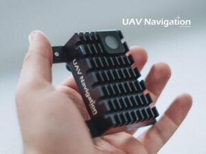
The VNS is designed to work with standard, mission-appropriate imaging sensors rather than extremely high-resolution or specialized optics. Rather than depending primarily on pixel count, the VNS relies on image consistency, sufficient texture, and stable contrast to support robust feature extraction.
Advanced image processing and AI-based algorithms compensate for variations in illumination, contrast, shadows, motion blur, and terrain appearance by normalizing image data and focusing on persistent visual features rather than absolute brightness values.
Visual Navigation & Global Shutter Sensors
The system’s effective navigation range is not defined by a fixed distance or altitude, but by the availability of meaningful visual features within the camera’s field of view. In practical terms, the VNS supports navigation from low to medium altitudes where sufficient ground texture is present. It operates within a sensor fusion architecture in the VECTOR autopilot, combining visual information with inertial data to continuously correct drift rather than functioning as a standalone positioning sensor.
The VNS exclusively uses global shutter sensors because they capture the entire image simultaneously, avoiding image distortion caused by platform motion and vibrations. This preserves geometric consistency and supports reliable feature extraction for visual navigation in dynamic flight conditions.
Sensor Integration & Connectivity
Sensor integration also requires consideration of latency, synchronization, robustness to vibration and motion, power consumption, environmental tolerance, and long-term reliability under operational conditions. The VNS has been computationally optimized to process image data efficiently while maintaining deterministic control loops. Instead of continuously storing or processing full images, it extracts and retains only relevant points of interest for navigation and mapping, reducing data volume, memory usage, and computational load.
Integration with the VECTOR autopilot provides precise timing, synchronization with inertial measurements, and deterministic data handling, enabling visual information to be fused with inertial data in real time as part of a fully integrated GNC ecosystem.
The VNS supports multiple standard communication options, including CAN, serial interfaces RS-232, and Ethernet, with the choice of interface typically determined by the customer and the constraints of the air vehicle or mission system. It can be integrated with UAV Navigation’s VECTOR autopilots as well as third-party avionics architectures. The connectivity and scalability of the VECTOR autopilot family also enable the integration of a wide range of peripherals, sensors, and mission-specific payloads alongside the VNS, supporting adaptability across complex or evolving mission profiles.
Read ‘How Visual Navigation Enables UAVs Operations in GNSS-Denied Environments’ for more information.