


Psionic is a developer of dual-use manned and unmanned navigation solutions that enable airborne and ground platforms to operate in the most challenging non-RF environments.
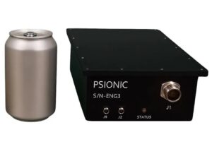
SurePath™ Ground-V
In this exclusive Q&A, DA sat down with Psionic to discuss the challenges of GNSS-denied navigation, the role of Navigation Doppler LiDAR (NDL) in contested environments, and the integration of SurePath™ Ground-V into military ground vehicle architectures.
Why is GNSS-denied navigation becoming such a critical challenge for modern defense vehicles and autonomous ground platforms?
Today’s operational environment is increasingly challenged by the use of Electronic Warfare (EW), specifically Electronic Attacks (EA), targeting the ability to determine location and successfully navigate within a given area of operation.
Unlike in the past, advanced EA capabilities are no longer limited to nation states. For a variety of reasons, the modern battlefield is now defined by non-state actors and rogue elements who have the ability to disrupt, jam, or completely deny access to GNSS navigation assets.
This environment is further complicated by the spoofing of location data, directly impacting the mission effectiveness of unsuspecting users. This new reality poses a substantial risk to military operations that are highly dependent on precise navigation solutions for both manned and unmanned assets.
How does Psionic’s Navigation Doppler LiDAR technology provide reliable navigation data without relying on GPS, satellite signals, or external networks?
SurePath™ is an NDL sensor based on intellectual property exclusively licensed from NASA. The system provides a highly accurate navigation solution with very low emissions and limited reliance on GNSS for system initialization, making SurePath™ well suited to covert operations or GPS-denied environments. SurePath™ gives the user a reliable navigation solution that is not susceptible to electronic attack, helping to maintain accurate and dependable navigation regardless of conditions within the electromagnetic spectrum.
What makes surface-relative velocity measurement especially valuable in contested environments where jamming, spoofing, or RF interference may be present?
Surface-relative velocity measurement is the foundational capability that separates truly assured navigation from RF-dependent navigation. This is especially important when operating in a Denied, Disrupted, Intermittent, and Limited (DDIL) environment, where RF-reliant navigation systems no longer operate efficiently, leaving them vulnerable to disruption, manipulation, or exploitation.
Surface-relative velocity measurement, as employed by SurePath™, derives motion data directly from the physical interaction between the platform and a physical surface. Once initialization is completed via GNSS, an external signal is only required periodically to maintain drift correction.
No RF transmission is made, and no adversary action against the electromagnetic spectrum can corrupt or manipulate the LiDAR measurement.
How does SurePath Ground-V support vehicle navigation across challenging terrain, including conditions where wheel slip or changing surfaces could affect traditional systems?
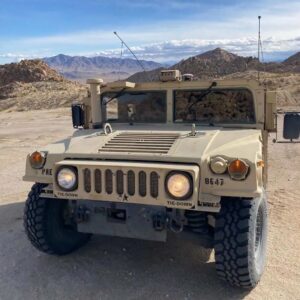
SurePath™ mounted to a Humvee, 2025
Traditional wheel-speed sensors assume the wheels are in continuous, consistent contact with the ground, and that rotation translates directly into forward movement. These assumptions are almost never true when traversing challenging terrain. Additionally, wheel slip, spin, skid, and surface variability all introduce errors that compound over time and degrade the navigation solution. These errors are further compounded in vehicles that use tracks.
SurePath™ takes a different approach by measuring velocity directly from the ground surface using NDL. By observing actual vehicle motion relative to the ground surface, rather than inferring it from wheel rotation, it delivers consistent, high-integrity navigation data across a wide range of terrain, surfaces, and environmental conditions that may not be well suited to traditional odometry-based systems.
This gives SurePath™ the ability to operate accurately in dynamic environmental conditions that would otherwise compromise traditional navigation data collection.
What are the key integration advantages of SurePath Ground-V for existing military vehicle architectures, including GNSS, inertial navigation, and MOSA-aligned systems?
Integration of new Assured Positioning, Navigation, and Timing (APNT) technology on military platforms continues to be a technical and budgetary burden for both prime contractors and military program managers. Advanced APNT systems must not only physically integrate within a platform chassis, but also be able to interface with both new and legacy systems that rely on navigation solutions for mission-essential tasks.
SurePath™ offers military vehicle programs a non-RF navigation enhancement built around interface and data interoperability standards designed to support integration with a vehicle’s existing architecture. SurePath™ specifically aligns with MOSA and CMOSS open architecture requirements to ensure data and interface interoperability.
Because SurePath™ is a platform-agnostic sensor and can be directly integrated with a vehicle’s existing GNSS system, it requires a minimal physical footprint for installation and data interfaces. This reduces both installation and financial risk to the platform.
Lastly, from an operational perspective, SurePath™ complements GNSS navigation in non-contested environments and corrects inertial drift when GNSS is not available due to jamming and/or spoofing. This makes SurePath™ a low-risk, high-gain navigation capability suited to challenging operational environments.
Which defense applications could benefit most from this technology, such as Intelligence, Surveillance, and Reconnaissance (ISR), logistics, convoys, strike missions, or Autonomous Ground Vehicles (AGVs)?
Because all mission sets require navigation certainty, it is difficult to identify a single application as more important than another. SurePath™ gives the user a reliable navigation solution that is not susceptible to electronic attack, supporting accurate and dependable navigation regardless of conditions within the electromagnetic spectrum.
Logistics and supply chain operations, ISR missions, strike missions, and autonomous vehicle operations each represent critical use cases where assured PNT directly determines mission success or failure. In each case, PNT becomes a foundational requirement rather than a supporting capability.
SurePath™ provides critical position and orientation data within each of these missions by mitigating the effects of electromagnetically denied conditions across varied terrain and environmental settings.
Thank you for your time. It has been a pleasure speaking with Psionic, and we look forward to following the continued development and adoption of GNSS-denied navigation technologies across defense and autonomous ground vehicle applications.