





CRFS outlines how passive Radio Frequency (RF) sensing can support drone detection, waveform analysis, geolocation, and integration with wider Counter-Uncrewed Aircraft System (C-UAS) architectures.
Passive RF sensing provides continuous monitoring of the electromagnetic spectrum to detect RF signals associated with drones and their operators. CRFS uses non-library-based detection, customizable signal detectors, and Signal Discovery software to detect new or previously unseen RF activity.
Once an RF signal has been detected, operators can examine the waveform to help classify it as friendly, hostile, or unknown. CRFS describes the capability through four stages: detect, recognize, identify, and locate. This can provide early warning of drone activity, support threat assessment, and help locate both the drone and its operator.
Integration into Multi-Layered C-UAS Architectures
The resulting RF intelligence can be fused with radar, Electro-Optical and Infrared (EO/IR), and acoustic sensor data to provide a clearer understanding of the threat. CRFS identifies multi-layered systems as the most robust approach, with Open Application Programming Interfaces (APIs) allowing RF intelligence to be fed into existing Command and Control (C2) software to support threat prioritization and the cueing of effectors such as guns or jammers.
RF sensors can be deployed on fixed infrastructure, vehicles, rapidly deployable systems, or uncrewed systems. As illustrated in the example site architecture, multiple RFeye Nodes provide RF monitoring around a site using MANET-A mesh radios, with RFeye Site forming part of the wider architecture.
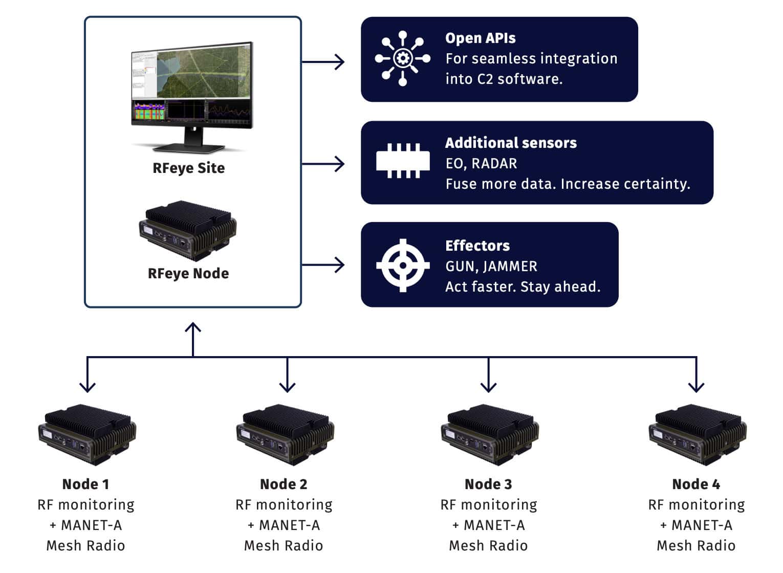
Example site architecture
Passive monitoring can detect numerous RF emitters simultaneously, supporting operations in drone-swarm scenarios. Highly accurate Time Difference of Arrival (TDoA) is available for signals detected at approximately 7 km, with line-of-bearing used for signals outside this range.
Automated detection and alerting enable persistent monitoring while reducing reliance on continuous manual observation. Holdover modules allow sensors to continue operating in Global Navigation Satellite System (GNSS)-denied environments, while the sensors can also be used to identify the location of a jammer.
In one example simulation, a drone flying at an altitude of 100 m and a speed of 50 mph produced detection and geolocation coverage of up to 6.5 km at 2.4 GHz, providing four minutes and 50 seconds of early warning. At 5.8 GHz, detection and geolocation coverage reached up to 3.5 km, providing two minutes and 40 seconds of early warning.
CRFS identifies 2.4 GHz as the standard Commercial Off-the-Shelf (COTS) frequency used for most Unmanned Aerial Vehicles (UAVs) and modified drones, while 5.8 GHz is used by some malicious drones and by disguised military UAVs not operating at 2.4 GHz.
Visit the CRFS website for more information on its RF sensing technology for drone detection and geolocation.