




Tilak.io develops navigation software for defense UAVs and autonomous systems operating in electronic warfare environments. Its work addresses the full sequence of GNSS disruption, including simulation, detection, mitigation, and system response under jamming and spoofing conditions.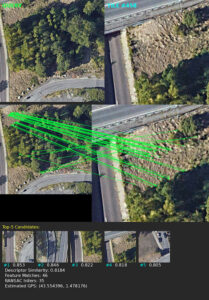
The software is intended to help prevent unreliable navigation data from affecting vehicle control. Tilak.io’s approach therefore extends beyond identifying interference, addressing how compromised position information is detected and managed during operation.
Addressing GNSS Failure During Defense Operations
GNSS disruption can produce several operational effects, including loss of telemetry, degraded video links, and sudden or significant position errors.
Tilak.io develops software that identifies compromised navigation inputs before inaccurate data affects system behavior. The objective is not only to detect an anomaly, but also to prevent incorrect position information from propagating through the flight-control system and causing unsafe responses.
Detecting Disruption Through Sensor Cross-Validation
A central requirement in GNSS resilience is determining when incoming position data can no longer be trusted. Tilak.io uses detection methods that examine signal-quality indicators and evaluate the consistency of navigation estimates derived from GNSS, inertial measurements, and other onboard sensors.
Altitude data requires particular care because individual sensors may use different reference frames. Barometric altitude is typically referenced to mean sea level, while GNSS altitude may be measured against an ellipsoid such as WGS 84. Rangefinders instead measure distance to the local ground surface.
These values cannot be compared directly until their separate reference systems have been taken into account.
Within the flight controller, the Kalman filter monitors the consistency of inertial and GNSS-derived position estimates. Increasing bias, residual values, or divergence within the filter may indicate that the position solution is becoming less reliable.
The output is not treated as simply valid or invalid. Quality indicators are instead used to estimate the accuracy of and confidence in the Kalman filter’s position estimate. This helps the flight controller determine how much weight should be assigned to the available navigation solution.
Simulating Electronic Warfare Conditions
Tilak.io develops simulation environments that reproduce the effects of jamming and spoofing on navigation systems. These simulations are designed to generate representative failure modes within the Kalman filter, which fuses sensor data into coherent estimates of position and attitude.
Controlled simulation allows detection and mitigation methods to be developed and validated before field testing. Algorithms can be assessed repeatedly under defined conditions, supporting iterative refinement before deployment in contested environments.
Maintaining Operation Following GNSS Disruption
After disruption has been detected, the system must determine whether the mission can continue using alternative data sources. Tilak.io implements mitigation methods that use the remaining onboard sensors to maintain a degraded but functional navigation solution.
These methods may include dead reckoning, vision-based positioning, and other GNSS-independent techniques. Where sufficient data remains available, the system can continue operating with reduced positional accuracy while retaining control and mission capability.
When a complete navigation solution cannot be maintained, the software can support intermediate tactical responses. A UAV may, for example, navigate toward a previously known area of reliable signal reception.
This provides an opportunity to recover navigation capability without immediately terminating the mission, while continuing to apply defined safety constraints.
Adaptive Response and Failsafe Actions
Once GNSS disruption has been confirmed, the system transitions to a response based on mission context and operational phase. Tilak.io implements automated behaviors ranging from controlled mission aborts to more definitive safety actions.
Possible responses include predefined recovery maneuvers, logic for returning to a designated safe area, and activation of safety systems such as parachutes. The selected response is determined by system state and mission requirements, with the action proportionate to the level of risk.
Failsafe procedures are treated as a final measure rather than the default response. This allows the system to use a more flexible and context-aware approach to GNSS-denied operation.
Vision-Based Navigation in Fully Denied Environments
Tilak.io also develops vision-based navigation capabilities for UAVs operating without GNSS. Techniques including visual odometry, SLAM, and optical flow can provide continued position estimates using onboard visual data.
Combining these methods with disruption detection, electronic warfare simulation, mitigation logic, and automated response behaviors supports a layered approach to navigation resilience.
This approach supports the development of defense UAV systems intended to retain control and operational capability during GNSS jamming, spoofing, or complete signal denial.