Showcase your capabilities
If you design, build or supply Tactical Mapping Drones, create a profile to showcase your capabilities and connect with visitors who have an active requirement for your solutions.


Tactical mapping drones are integral to modern military GEOINT and ISR infrastructure, fundamentally changing how commanders acquire and utilize terrain intelligence. These advanced UAV systems are purpose-built with ruggedized airframes, secure data links, and high-fidelity sensor packages (including LIDAR, SAR, and EO/IR) to operate reliably within contested, GPS-denied environments.
This guide showcases suppliers of tactical mapping drones for high-resolution 3D geospatial data, dynamic elevation models, and geometrically corrected orthomosaics.
Read the Technology Overview


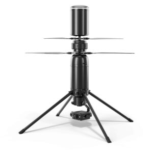
Compact UAS & Heavy-Lift Rotorcraft for Military ISR & Logistics Operations

NATO STANAG-Compliant Advanced UAV Platforms That Deliver Real-Time Intelligence & Mission Support Across Air, Land & Sea
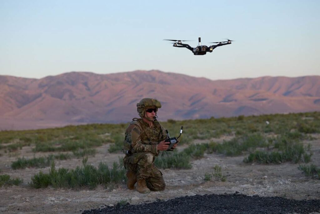
Autonomous UAV Platforms & Drone Services for Military, Government, Security & Emergency Response
Advanced American-Made Drone Technologies for Aerial ISR (Intelligence, Surveillance & Reconnaissance)

Manufacturer & Systems Integrator of Deployable Systems for Military, Government & Security Applications
UK Sovereign Autonomous Uncrewed Systems for Defence, Security & Critical Infrastructure

High-Performance VTOL Fixed-Wing UAVs for Defense, Government & Tactical Applications
If you design, build or supply Tactical Mapping Drones, create a profile to showcase your capabilities and connect with visitors who have an active requirement for your solutions.

Tactical mapping drones are driving the digital transformation of modern defense operations, supporting battlefield mapping and reconnaissance, targeting and fires coordination, as well as disaster response and combat engineering support. These Unmanned Aerial Vehicles (UAVs) provide a critical, real-time capability to capture, process, and distribute high-resolution Geospatial Intelligence (GEOINT), delivering precise terrain and situational awareness for mission planning, targeting, and combat engineering.
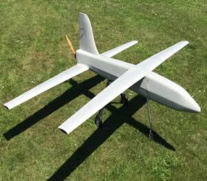
Sword 4.0 mapping drone from Cannon Defence & Security
Built with ruggedized airframes, advanced imaging payloads, and integrated mission computing, these systems are specifically engineered to operate within the complex, congested, and contested environments that define contemporary warfare, forming a vital link between traditional Intelligence, Surveillance, and Reconnaissance (ISR) functions and the forward-edge warfighter.
Tactical mapping drones are rigorously engineered to meet demanding military and intelligence requirements for security, durability, and precision. Their design philosophy mandates operation under threat conditions. This is reflected in their essential features: encrypted data links, robust anti-jamming and anti-spoofing protection, and compliance with stringent defense standards such as MIL-STD-810 (for environmental and operational qualification) and NATO STANAG 4586 (for control interoperability).
Within defense operations, these systems significantly extend the reach and vision of both ground and aerial units. They facilitate the rapid generation of highly accurate three-dimensional terrain models and high-resolution imagery. The resulting geospatial data supports not only traditional reconnaissance but also dynamic targeting, logistics optimization, and comprehensive mission rehearsal. As modern battlefields pivot decisively toward data-driven command, advanced mapping drones form the technological backbone of tactical decision support and crucial terrain awareness.
The agility and precision of tactical mapping UAVs unlock several mission-critical functions for military engineers and operational commanders.
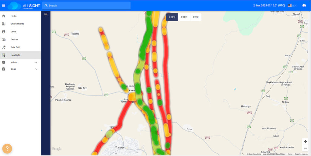
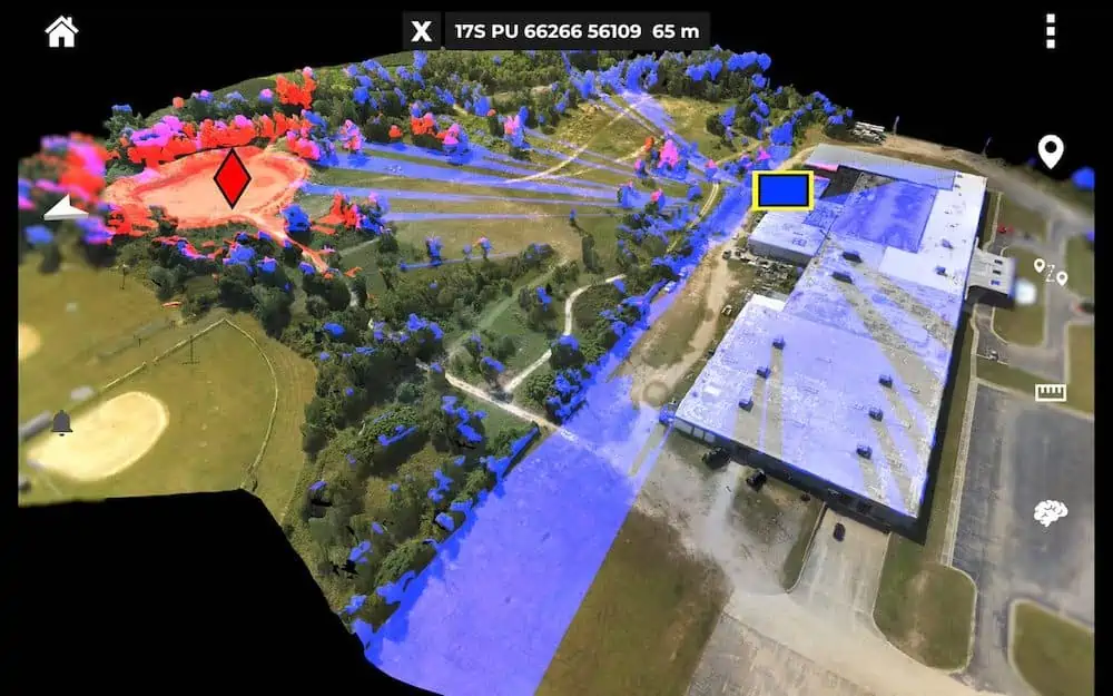
Tactical mapping drones deliver real-time 3D terrain data essential for mission planning and maneuvering. They establish a detailed digital foundation for optimizing route selection, determining defensive positioning, and executing crucial line-of-sight (LOS) analysis. When securely integrated with C4ISR networks, this mapping feed becomes a live, dynamic layer within the Common Operational Picture (COP), accessible from centralized command centers down to dismounted tactical troops.

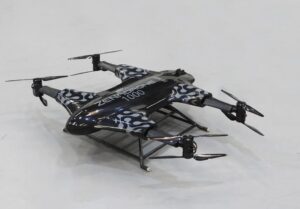
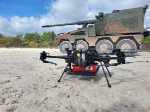
Edge 130 Blue UAS for mapping from Red Cat Holdings
A pivotal requirement for these systems is resilient navigation. In GPS-contested or denied environments, mapping drones shift from satellite-based positioning to advanced techniques like Terrain Relative Navigation (TRN) and Vision-Aided Navigation to maintain positional accuracy and ensure mapping capability when GNSS signals are jammed or unavailable.
The efficacy of artillery, mortar, and precision-guided munitions is directly tied to the availability of accurate elevation data. High-resolution Digital Elevation Models (DEMs) or structured Digital Terrain Elevation Data (DTED) are indispensable. Mapping drones rapidly supply this critical data, allowing fires teams to refine firing solutions and update target coordinates dynamically. Real-time geospatial overlays assist in both pre-mission planning and immediate battle damage assessment (BDA), drastically shortening the sensor-to-shooter timeline.
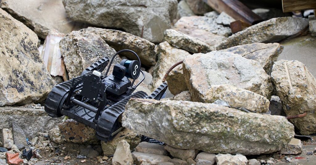
In the critical domains of combat engineering, infrastructure assessment, and post-conflict recovery, mapping UAVs prove invaluable. They swiftly survey damaged infrastructure, assess the integrity of bridges and roadways, and identify safe routes through hazardous zones. This dual-use capability supports both operational logistics and humanitarian assistance, providing commanders and planners with accurate situational awareness without needlessly endangering personnel.
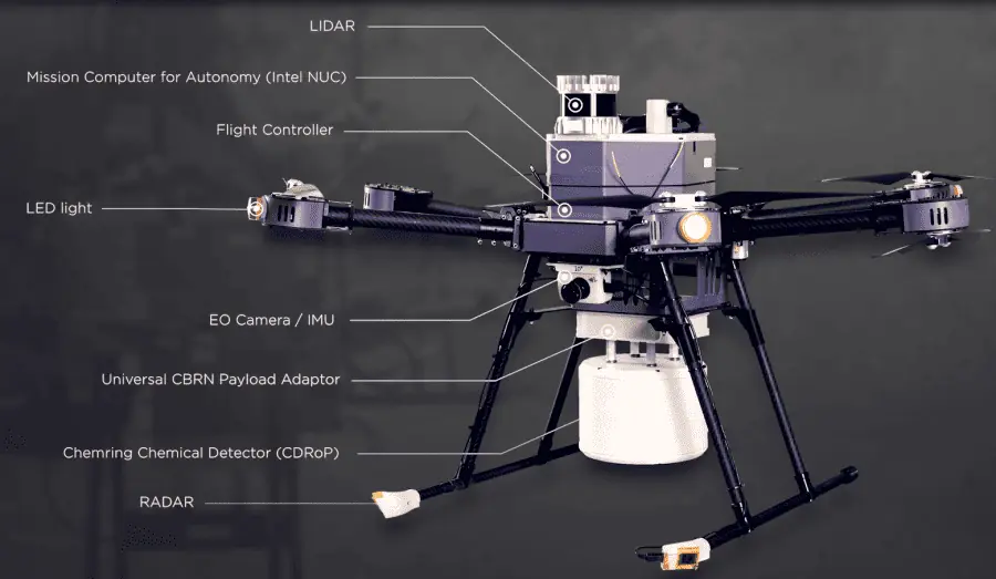
The versatility of a tactical mapping drone lies in its sensor suite, which combines diverse technologies to penetrate varied environmental conditions.

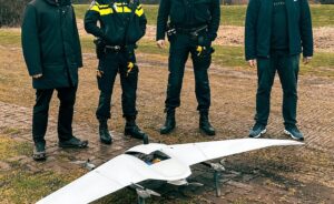
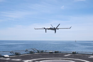
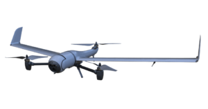
VTOne (BVT516), a long-endurance hybrid VTOL UAV for mapping from Beyond Vision
EO/IR sensors represent the foundational imaging payloads for tactical mapping. High-resolution EO cameras capture sharp visual terrain detail, while infrared sensors detect thermal variations, critical for applications like distinguishing recently disturbed ground, identifying hidden vehicles, or locating concealed personnel. The use of multispectral sensors further extends this capability by allowing the classification of materials and vegetation types, which is key for camouflage detection and terrain analysis.
Airborne LIDAR systems utilize pulsed lasers to create highly precise three-dimensional models of the terrain, offering the distinct advantage of penetrating light vegetation. Photogrammetric mapping drones employ overlapping high-resolution images, coupled with onboard Simultaneous Localization and Mapping (SLAM) algorithms, to reconstruct terrain geometry in near real-time. These sophisticated payloads are capable of achieving sub-meter vertical accuracy, a requirement that supports detailed mission rehearsal and the generation of digital twins for complex defense scenarios.
SAR-equipped UAVs offer unparalleled all-weather and day/night imaging capability, allowing persistent coverage regardless of atmospheric conditions (clouds, smoke) or darkness. SAR mapping drones are strategically valuable in ISR and targeting missions. Their ability to derive elevation data and detect subtle surface changes, such as tire tracks or disturbed earth, makes synthetic aperture radar a potent strategic asset for terrain intelligence and the detection of buried or camouflaged threats.
Operators may leverage a range of UAVs configured for mapping and reconnaissance missions, with platform selection determined by endurance requirements, area coverage, launch and recovery constraints, and the operational environment. These platforms include:
Tactical UAVs rely on robust hybrid GNSS/INS navigation systems, which fuse satellite-based positioning with high-grade inertial sensors. This combination ensures precise tracking and minimal drift even when GNSS signals are severely degraded or jammed. Advanced systems further bolster this with Vision-Aided Navigation Systems (VINS), utilizing onboard imagery and terrain correlation techniques to refine the location data against stored maps.
For battlefield mapping, data integrity is paramount. Every image, metadata file, and data packet must be time-synchronized and cryptographically verified. This rigorous process is essential to ensure the undisputed integrity of the information disseminated into C4ISR networks and fire-control systems.
Artificial Intelligence (AI) is rapidly transitioning tactical mapping into a highly autonomous process. AI-based change detection algorithms can automatically highlight newly constructed defenses or altered landscapes. Furthermore, automated feature extraction converts raw imagery into structured geospatial layers, ready for immediate command consumption.
Looking to the future, hyperspectral sensors offer new dimensions of mapping fidelity by detecting material composition. While still nascent, concepts like quantum-enhanced sensors promise the potential for detecting subsurface features currently invisible to standard sensors. Edge computing is already a deployable reality, allowing the onboard generation of orthomosaics and elevation models directly on the drone, drastically minimizing latency and enabling the near-instantaneous GEOINT dissemination critical for the tactical battlefield network.


 Searching Companies & Products


 Subscribe to the Weekly eBrief
The latest engineering and technical developments straight to your inbox - join thousands of engineers who receive it.
Subscribe to the Weekly eBrief
The latest engineering and technical developments straight to your inbox - join thousands of engineers who receive it.