Showcase your capabilities
If you design, build or supply LiDAR Systems, create a profile to showcase your capabilities and connect with visitors who have an active requirement for your solutions.


Military LiDAR systems are laser-based sensing solutions that generate three-dimensional spatial data for defense mapping, navigation, surveillance, and targeting applications. Deployed across aircraft, UAVs, ground vehicles, dismounted soldier systems, fixed sites, and maritime platforms, these systems support obstacle detection, autonomous route planning, and perimeter security.
This page showcases leading military LiDAR suppliers and manufacturers offering airborne LiDAR scanners, vehicle-mounted sensors, portable units, security LiDAR, and maritime configurations.
Read the Technology Overview
Advanced Solutions for Defense Modernization: Propulsion, Sensors, Communication & Augmented Reality Systems
Tactical Grade IMU, GPS/INS, Weapon Orientation Solutions
If you design, build or supply LiDAR Systems, create a profile to showcase your capabilities and connect with visitors who have an active requirement for your solutions.

Military LiDAR systems have become an important sensing technology across defense operations. By transmitting laser pulses and measuring the time taken for reflected energy to return from a target, these optical systems generate three-dimensional representations of the surrounding environment. These spatial datasets provide military operators with a level of precision that is difficult to achieve using conventional sensing technologies alone.
Modern military LiDAR is employed across air, land, and maritime domains to support intelligence gathering, tactical navigation, autonomous operation, force protection, surveillance, and precision targeting. Unlike traditional imaging setups that rely primarily on visual information, a dedicated LiDAR sensor creates geometric models of terrain, structures, vehicles, and personnel, enabling situational awareness in both day and night conditions.

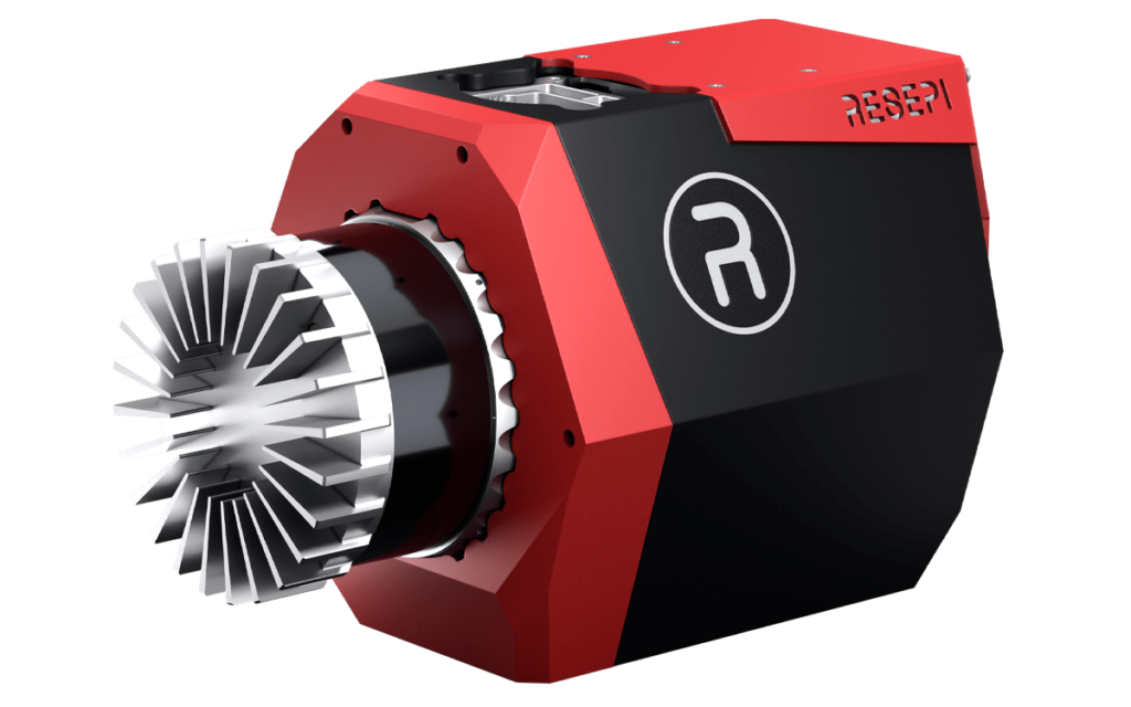
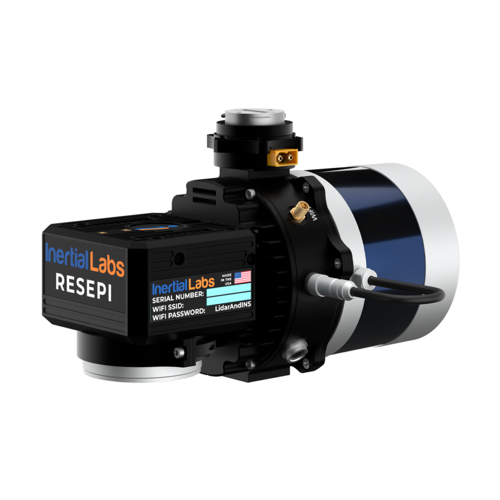
RESEPI LiDAR & Sensor Fusion Platforms by Inertial Labs
Airborne LiDAR platforms provide large-area terrain mapping, reconnaissance, and intelligence collection capabilities. Installed aboard fixed-wing aircraft, helicopters, and unmanned systems, these systems collect elevation and surface data over defined areas.
Military airborne LiDAR is used to generate digital terrain models, identify obstacles, assess mobility corridors, support mission planning, and provide high-resolution geospatial intelligence. In contested environments, an airborne LiDAR system can survey operational areas without requiring personnel to enter hazardous locations. The use of unmanned aircraft has expanded the deployment of tactical drone LiDAR payloads, providing persistent collection capabilities while reducing risk to tactical personnel.
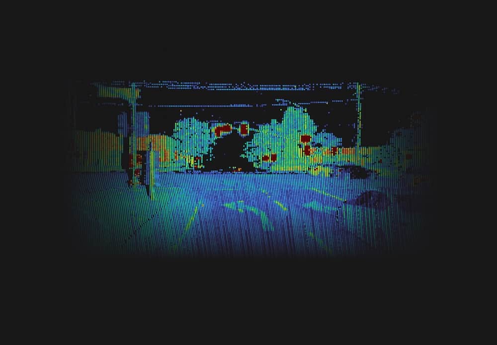
Vehicle-mounted LiDAR systems provide real-time environmental awareness for armored vehicles, reconnaissance platforms, logistics vehicles, and autonomous ground systems. These sensors scan the surrounding environment, generating three-dimensional data that supports navigation, obstacle detection, route planning, and force protection.
Integrating a LiDAR unit into military vehicles requires ruggedized systems capable of maintaining performance under vibration, shock, dust, mud, and temperature extremes. Engineers couple these sensors with rugged computer systems with LiDAR processing capabilities to handle high-rate point clouds in real time. Tactical configurations may also feature an integrated LiDAR turret to maintain a 360-degree field of view around the vehicle perimeter.
Portable LiDAR units enable military personnel to capture and analyze operational environments. These compact solutions are used for tactical reconnaissance, route assessment, facility mapping, and urban operations where environmental understanding is required.
Soldiers can utilize a man-portable LiDAR device for localized mapping tasks. Advances in miniaturization continue to reduce the size, weight, and power requirements of the core sensor, making these systems practical for dismounted applications.
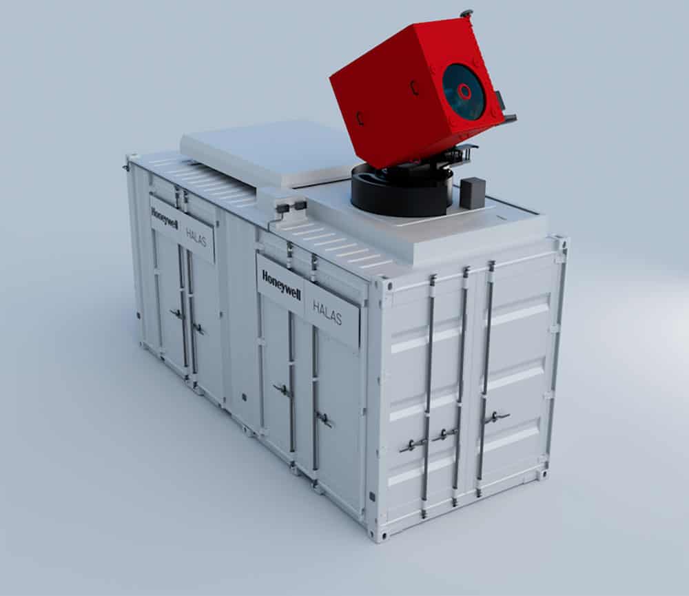
Fixed installations employ security LiDAR for perimeter monitoring, intrusion detection, and surveillance of facilities. These systems create persistent three-dimensional security zones capable of identifying, tracking, and classifying threats approaching protected assets. Compared with conventional camera systems, enhancing security with LiDAR offers spatial awareness and provides target positioning information in low-light or zero-light conditions.
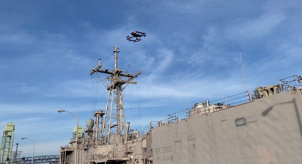
Maritime LiDAR systems support navigation, surveillance, obstacle detection, and autonomous vessel operation. Surface combatants, patrol vessels, Unmanned Surface Vessels (USVs), and Unmaned Underwater Vehicles (UUVs) utilize specialized LiDAR products to improve situational awareness and for Anti-Submarine Warfare (ASW), although underwater performance is limited by water clarity, turbidity, and operating range.
In these environments, hardware like a specialized LiDAR buoy can be deployed for coastal monitoring and threat detection. These marine-grade systems must withstand conditions including salt exposure, high humidity, vibration, and electromagnetic interference.

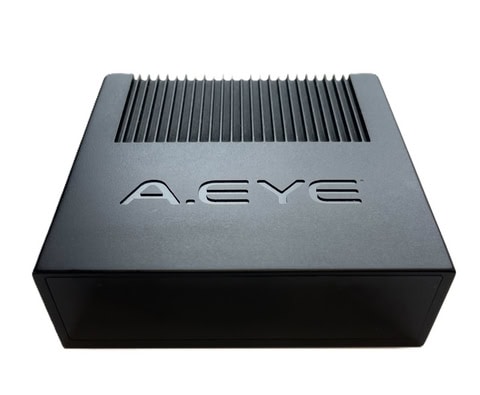
SurePath ground-V LiDAR Sensor for precision navigation by Psionic
LiDAR serves as a primary sensor enabling autonomous military operations across Unmanned Ground Vehicles (UGVs), Unmanned Aerial Vehicles (UAVs), and maritime autonomous systems. By generating three-dimensional environmental data, these platforms can detect obstacles, identify navigable routes, and operate in dynamic environments.
For UGVs, integrated LiDAR sensors support terrain analysis, obstacle avoidance, and autonomous route execution. UAV LiDAR sensors are used to execute low-altitude navigation, terrain following, landing assistance, and collision avoidance. Similarly, maritime autonomous platforms use specialized LiDAR for surface vessels to achieve vessel detection and obstacle avoidance in coastal environments.
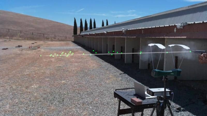
A valuable LiDAR military application is navigation, often using NDL (Navigation Doppler LiDAR) systems, to generate three-dimensional representations of operational environments. Through Simultaneous Localization and Mapping (SLAM), platforms equipped with a LiDAR scanner can map unfamiliar environments while determining their own position. This capability is useful for navigation in GPS-degraded or GPS-denied environments where conventional navigation methods are unreliable.
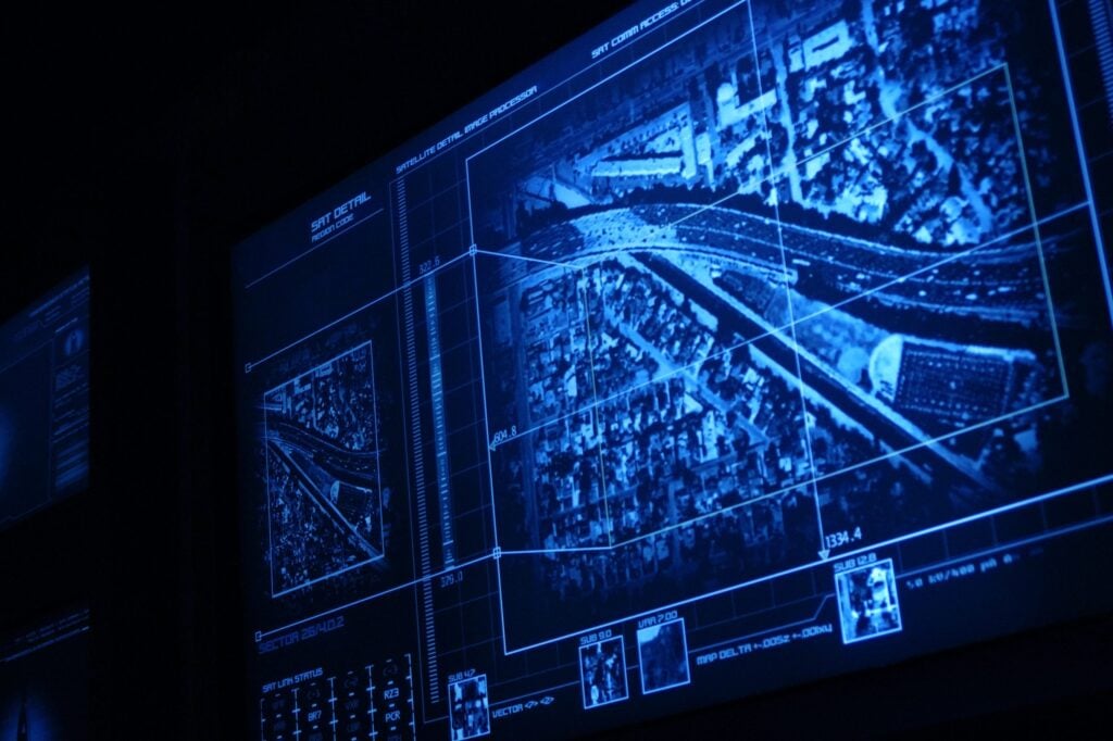
The terrain intelligence generated by these systems supports route selection, mobility analysis, mission planning, and operational rehearsals. Three-dimensional battlespace visualization provides commanders with situational awareness, improving operational decision-making across command levels.
Military installations utilize LiDAR surveillance architectures to provide monitoring of assets and infrastructure. These systems combine raw sensor data with analytics to detect, track, and classify personnel, vehicles, and low-flying aerial threats.
The spatial information generated by long range LiDAR supports threat assessment and operator awareness. When integrated with wider security architectures, LiDAR can contribute to target recognition, weapon cueing, and engagement workflows by providing accurate positional data for command systems, remote weapon stations, or other sensor and effector networks. It also supports Counter-UAS operations by detecting and tracking small drones that are difficult to identify using conventional radar or optical surveillance technologies alone.
Modern battlespace effictiveness relies on combining data streams across multiple domains to build an operational picture.
These combined streams ensure operational continuity across shifting combat environments.
Deploying military sensor systems requires adherence to international defense regulations, environmental grading, and secure supply chain mandates.
Compliance with these frameworks is often required for formal platform adoption, depending on the procurement program, operating environment, and host platform.
The evolution of optical components, solid-state electronics, and signal processing continues to redefine defense sensor capabilities.
These technological developments continue to shift the baseline of modern reconnaissance capabilities.


 Searching Companies & Products


 Subscribe to the Weekly eBrief
The latest engineering and technical developments straight to your inbox - join thousands of engineers who receive it.
Subscribe to the Weekly eBrief
The latest engineering and technical developments straight to your inbox - join thousands of engineers who receive it.