Ground Control discusses why Assured Positioning, Navigation and Timing (A-PNT) is emerging as a key technology for maintaining trusted positioning in Beyond Visual Line Of Sight (BVLOS) drone operations.
As Unmanned Aerial Vehicles (UAVs) missions expand into complex and signal-challenged environments, reliable Positioning, Navigation, and Timing (PNT) data is essential for safe operation, regulatory compliance, and mission continuity.
 Global Navigation Satellite Systems (GNSS) such as GPS, Galileo, GLONASS, and BeiDou have long supported UAV navigation, enabling functions including waypoint navigation, path planning, geofencing, obstacle avoidance, and automated safety procedures. However, because GNSS signals originate from satellites thousands of kilometers away, they arrive at Earth with relatively low power and are vulnerable to interference, obstruction, jamming, and spoofing.
Navigation Challenges for BVLOS UAVs
Ground Control explains that GNSS disruption is increasingly observed in both military and civilian environments. Jamming can overwhelm legitimate satellite transmissions, while spoofing introduces deceptive signals that cause receivers to calculate incorrect locations.
In addition, many operational environments naturally degrade satellite reception. Dense urban areas can reflect signals from buildings, creating multipath errors, while industrial facilities may generate electromagnetic interference. Rural regions, mountainous terrain, and maritime environments can also produce signal shadows or reduced satellite visibility.
When trusted PNT data becomes unreliable, UAVs may lose confidence in their location and timing. For BVLOS operations, which depend heavily on automated navigation and remote oversight, this uncertainty can interrupt missions and trigger safety procedures.
A-PNT as a Resilient Navigation Approach
To address these challenges, Ground Control highlights the role of A-PNT. A-PNT introduces a layered navigation architecture that supplements GNSS with alternative positioning sources capable of maintaining reliable navigation when traditional satellite signals degrade.

One such source is derived from the Iridium low Earth orbit satellite constellation. Because these satellites orbit significantly closer to Earth than GNSS satellites, their signals are considerably stronger and more resistant to interference and obstruction.
Hybrid navigation systems can combine GNSS positioning with Iridium-derived PNT signals when both sources are available. If GNSS becomes unreliable or unavailable, the system can continue operating using Iridium signals alone, helping maintain navigation continuity. Iridium PNT signals also include authentication capabilities that allow receivers to verify signal integrity and reject manipulated data.
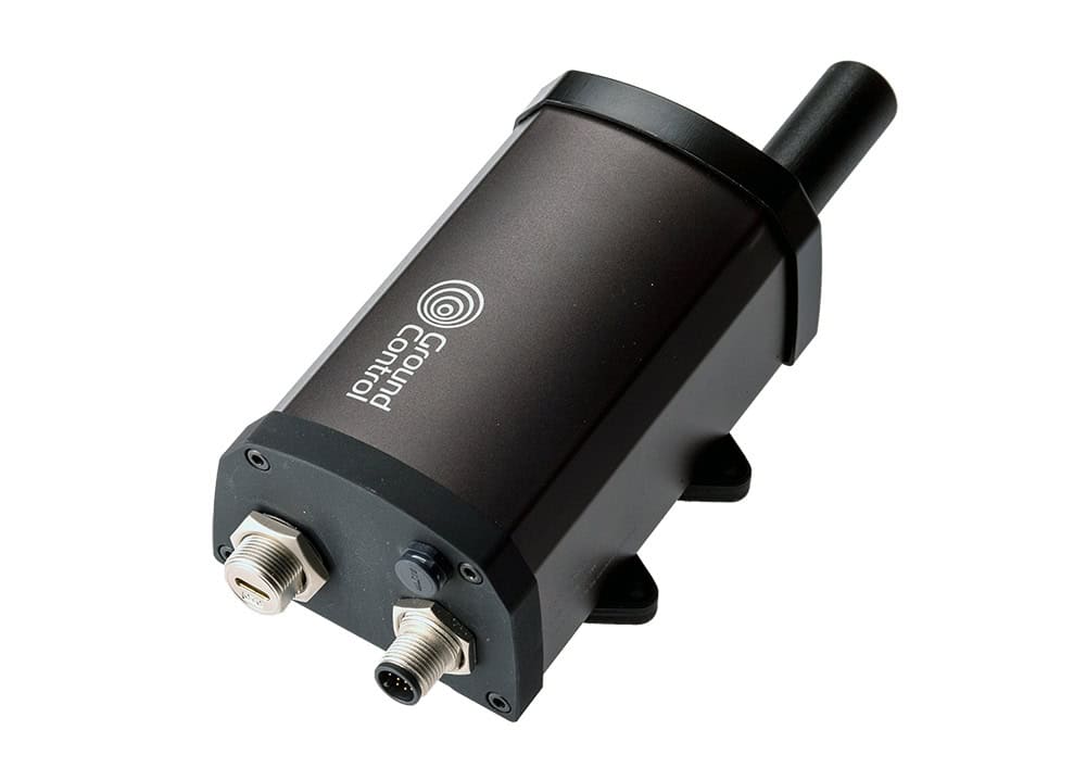
RockBLOCK APNT for UAV Platforms
Ground Control supports this approach through its RockBLOCK APNT device, a compact satellite unit designed for integration with UAVs and other autonomous platforms. The device integrates Iridium-based PNT with multi-constellation GNSS reception, providing an additional source of trusted positioning data when GNSS signals cannot be relied upon.
RockBLOCK APNT features a compact form factor with low size, weight, and power requirements, enabling integration into existing UAV navigation stacks. The unit supports serial, USB-C, and Bluetooth connectivity and is housed within an IP66-rated enclosure designed for demanding operational environments.
The device incorporates twin antennas to improve sky visibility and signal resilience depending on the UAV’s configuration. In addition to navigation capabilities, RockBLOCK APNT supports two-way satellite messaging with data transfers of up to 100 KB, offering a fallback communication pathway if other links fail.
Strengthening Navigation Resilience
According to Ground Control, combining GNSS with alternative satellite positioning sources such as Iridium PNT reduces reliance on a single navigation system and improves operational resilience. By validating positioning data across independent sources, UAV platforms can detect anomalies caused by interference or spoofing and maintain trusted navigation.
As BVLOS drone operations expand into increasingly complex environments, A-PNT architectures provide a practical approach to ensuring reliable positioning and supporting continuous autonomous operations even when GNSS signals are degraded or unavailable.
Find out more about A-PNT and RockBLOCK APNT via the Ground Control website.