Discover Leading Defense Technology Solutions
Discover cutting-edge solutions from leading global suppliersSchneider Digital has released an article explaining how its professional 3D stereo visualization for GEOINT and immersive, virtual simulation environments can be used for military applications.
All over the world, armed forces use digital, 3D stereoscopic displays in a variety of application areas, especially for ‘Geospatial Intelligence’ (GEOINT), as well as for immersive, virtual simulation environments. Important GEOINT software applications in the COTS (commercial off-the-shelf) area include Socet GXP from BAE Systems, Collins Sci-X and ArcGIS Pro from ESRI, plus a variety of other GIS, remote sensing and photogrammetry applications from Hexagon, Trimble and Bentley and by other software manufacturers.
Even with comparatively inexpensive hardware and software, which are commercially available today, a large number of flexibly configurable resources are already placed in the hands of GEOINT specialists. The tasks that can be performed optimally and efficiently with the help of digital, stereoscopic visualization technology include the following areas of application:
- Classic GEOINT tasks in a C3 / C4i environment include the stereoscopic exploitation of high-resolution and multispectral satellite images, for instance commercially available WorldView-3 pan-sharpened images with currently 30cm true ground resolution, or wide-area stereoscopic coverage from panchromaticWorldView-1 satellite images with 50cm resolution;
- Tactical reconnaissance with airborne EO Recce sensor systems, for instance Tornado or Heron TP;
- Realistic building textures for individual objects, but also mesh-based, complex 3D city models for simulation and virtual training environments, especially for output to VR and AR glasses, helmets, or head-mounted devices (HMDs);
- 3D stereo instruction and deployment preparation for special forces;
- Location simulation and optimization of stationary monitoring systems, e.g. for securing field camps and other critical infrastructures;
- 3D spatial data integration in GIS environments, development of mobile, military ‘apps’ for use with lenticular, small-format stereoscopic screens;
- Real-time display of stereoscopic video images, first-person view systems (FPV) for reconnaissance drones or remote-controlled systems, for instance for UXO clearance;
- High-resolution 3D terrain display, integration of orthorectified image-textured surfaces and relevant objects in GEOINT:
- Precise visibility analysis; o Accessibility / track analysis for ground units;
- Programming of missiles or UAS with accurately measured, semantically enriched, multimodal (visual, RADAR, LiDAR) and multiply redundant navigation data;
- Logistics planning, construction of temporary supply and field camp structures, planning and execution of all infrastructure projects at armed forces locations.
GEOINT applications have always been the key area for stereoscopic visualization technologies. The origins go back to the First World War, when aerial photographs and binocular, stereoscopic viewing were used to identify artillery targets and map the trenches in Flanders. Today, digital, stereoscopic 3D visualization is primarily used to display geospatial information correctly in 3D-stereo, to analyze it and to generate precise, as complete as possible data sets with the help of GIS, mapping, photogrammetry and remote sensing tools.
3D-stereo evaluation and analysis for GEOINT
Today’s IT infrastructure, the performance of professional software and hardware, make it possible to create very large and complex 3D mesh or 3D point cloud environments, which may reach down to a few centimeters ground resolution in positional accuracy and detail. Special modeling software, for example SURE from nFrames or Skyline Terra Software, is used in combination with game engines such as Unity3D and Unreal, for ultra-fast rendering of 3D scenarios and the stereoscopic output of hybrid geospatial datasets.
With the help of game engine technology, realistic 3D ‘avatar’ models for vehicles, ships and aircraft can be integrated to virtually simulate a comprehensive and realistic representation of situational scenarios and tactical order-of-battle displays. Today, the efficient transmission and stereoscopic display of terabyte-sized, encrypted data records can now be carried out in almost real time inside secure networks with browsers such as Euclideon and Cesium. Such capabilities enable a wide range of new possibilities, such as the transition from local, VR ‘island solutions’ to a theoretically globally available client-server IT architecture that is configured redundantly and inherently decentralized, accessed by stereo-capable ‘thin client’ display stations of any type and screen size.
Different stereoscopic visualization technologies – suitable for every requirement
Various stereoscopic visualization technologies have been developed for different military areas of application and requirements, which can be assigned to three main environments:
Visualization for personal / individual use:
- Head-Mounted Displays (HMDs) are often used for personal, immersive viewing of virtual environments;
- Augmented Reality (AR) glasses and helmets mirror 3D spatial information into the real environment, whereby the user’s view direction is precisely measured by eye-safe micro-lasers or cameras;
- Autostereoscopic (glasses-free) single-screen displays with eye-tracking sensor, stereoscopic image resolution reduced by 50%;
- Active LCD shutter glasses have been in use for over 30 years, at first with single CRT, then TFT screens with 120Hz stereo switching. They were supported only by NVIDIA graphic cards and software drivers until 2018. Still in use, since 2020 no longer compatible with Windows 10; to be rated as ‘EOL’ (end-of life).
Workplace visualization – for smaller groups:
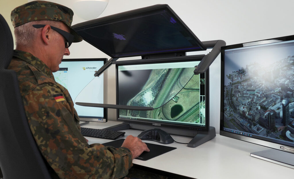
- High-resolution 3D PluraView stereo monitors with up to 8.3 megapixel (UHD) per screen; ideally suited for permanent use by GEOINT analysts to capture data, interact with geospatial datasets; also suitable for smaller groups of viewers. Technology is based on linear, cross-polarized filters and passive, polarized stereo glasses; maximum practicality and compatibility with currently more than 200 stereocapable software applications, supported by NVIDIA and AMD;
- Autostereoscopic (glasses-free) displays with a lenticular foil applied; limited in size and also by fixed number of autostereoscopic positions in front of the screen. Stereoscopic image information replicated for each viewing position, i.e. reduction of resolution by a factor identical to the number of viewing positions.
- In the prototype stage: first, autostereoscopic holographic or light field projection systems with 360- degree visibility, primarily for 3D situational displays, currently with limited possibilities for interaction and compatibility with software applications.
- Large-format, line-polarized, single-screen passive LCD monitors with diagonal sizes of up to 100 inches. Can be used for display at a greater viewing distance (> 2m). Not suitable for interactive data capture or analysis since sufficient stereo image resolution is not (yet) achieved.
Larger group visualization:
- Stereoscopic large-format VR walls (Schneider Digital ‘smartVR’ Wall) and immersive 360-degree VR ‘caves’ are used for larger audiences in operation centers and control rooms; based on 120Hz active stereo technology, in combination with LCD shutter glasses.
For military use, the Schneider Digital stereoscopic display systems offer the highest resolution, image brightness and maximum ergonomics for fatigue-free work and flexible use with a large number of software applications.
Both the passive 3D PluraView monitors and the active smartVR / smart3D Wall do not require any proprietary graphics drivers and can be operated with professional NVIDIA and AMD graphics cards.
In combination, the Schneider Digital displays cover all requirements, from the acquisition and analysis of GEOINT data to large format data presentation in stereoscopic simulation environments.