Non-GPS Navigation Developed for GPS-Denied Environments 

Scientific Systems has extended and demonstrated its image-based solution during flight operations ranging from 25,000ft down to 200ft in response to upgraded EW capabilities By Abi Wylie / 26 Feb 2024

GPS Denied Navigation

Discover cutting-edge solutions from 6 leading global suppliers
SUPPLIER SPOTLIGHT
Non-GPS Navigation Developed for GPS-Denied Environments
Follow DA

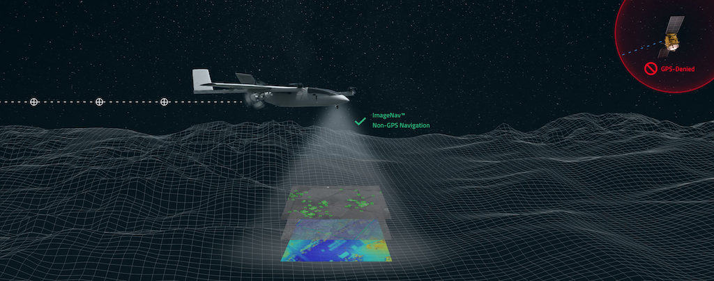
Scientific Systems, an industry leader in advanced artificial intelligence for defense applications, is continuing development of ImageNav™, the company’s non-GPS, image-based, precision navigation software. 

The company has recently extended and demonstrated its image-based GPS-denied navigation solution during flight operations ranging from 25,000 feet down to 200 feet. ImageNav has been developed for over a decade with funding totaling more than $45 million.

For many air vehicle flights, the military relies on the Global Positioning System (GPS) for navigation, risking exposure to electronic jamming in contested environments. News outlets have reported that certain countries have significantly upgraded their electronic-warfare capabilities and have disabled sophisticated missiles by scrambling their GPS coordinates.

ImageNav provides accurate navigation, without GPS, for a range of systems, including weapons, aircraft, and uncrewed aircraft systems (UAS).

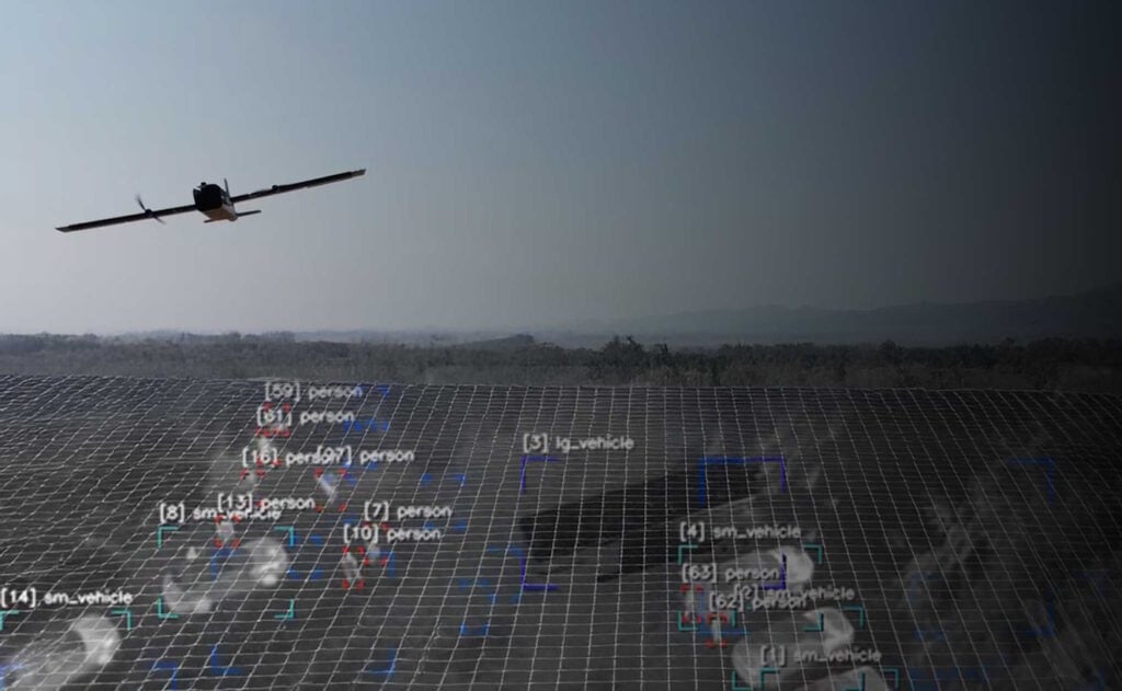
ImageNav software computes both absolute and relative navigation position updates by fusing the output of three different algorithms: stereo terrain correlation, image-based feature matching, and feature-based velocity estimation. Stereo terrain correlation collects a series of overlapping images from a flight path using an onboard electro-optical (EO) or infrared (IR) digital camera. 

Absolute position fixes are computed by correlating stereo elevation models from the captured imagery with stored terrain references to determine the precise geo-location. Image-based feature matching matches image features in captured imagery with stored image references. Lastly, feature-based velocity estimation tracks image features from frame to frame to constrain inertial navigation drift between position updates. 

ImageNav uses all three of these algorithms, running in parallel, to produce a robust, GPS-like position that is immune to jamming.

ImageNav runs entirely “at-the-edge” with minimal size, weight and power requirements. It can be integrated onto air platforms with existing sensors and processors as a software only upgrade, as software on a stand-alone processor board, or as a self-contained hardware payload (e.g. camera, processor, inertial measurement unit (IMU)).

Scientific Systems has multiple efforts underway to integrate ImageNav onto GPS-guided munitions and UASs, enabling them to operate in GPS-denied environments. A recent live weapon drop test demonstrated that ImageNav can navigate a weapon during flight, without GPS, enabling it to hit the target within the required performance envelope.

“ImageNav is an innovative, compact solution that helps air vehicles generate accurate position fixes in the most challenging environments,” said Tom Frost, Senior VP of the Products Division at Scientific Systems. “Recent reports of successful efforts to jam weapons and aircraft that rely on GPS underscore the immediate need to develop a reliable non-GPS guidance system.”

Posted by Abi Wylie Edited by Abigail Wylie, Editor and Copywriter experienced in digital media with a keen interest in ocean science technology. Connect & Contact

Latest Articles

GA-ASI & Marine Corps Advance MQ-9A Operational Capabilities

The U.S. Marine Corps has accumulated over 1,000 flight hours using the MQ-9A unmanned aircraft in collaboration with General Atomics Aeronautical Systems, Inc. (GA-ASI)

Apr 30, 2025
New ESTU Module to Boost Short-Term Stability of Optical Cesium Clocks

Adtran has launched the Enhanced Short-Term Unit (ESTU) for its OSA 3300 optical cesium clocks, delivering passive hydrogen maser-level stability and significantly enhancing precision timing for defense applications

Apr 30, 2025
Sky Power to Showcase ISR UAV Propulsion Technology at XPONENTIAL 2025

Sky Power International will present advanced UAV propulsion technologies at XPONENTIAL 2025, highlighting powerful engines, hybrid systems, and customized solutions for ISR and civilian applications

Apr 29, 2025
Full Ground Autonomy Integrated into Army SMET Vehicle for Uncrewed Breaching

Overland AI demonstrated its latest autonomous ground breaching capabilities at Project Convergence Capstone 5, integrating advanced software, hardware, and aerial payloads for Army experimentation

Apr 29, 2025
Application of Wheel Speed Sensors in INS

Micro-Magic delves into how wheel speed sensors are often used as auxiliary sensors in INS to improve navigation accuracy and suppress accumulated errors of inertial sensors

Apr 28, 2025
Product Spotlight: The Honeywell HG4930 IMU

Honeywell highlights the key features and reliability of the Honeywell HG4930 IMU, a trusted solution for navigation in GNSS-denied environments and challenging conditions

Apr 28, 2025

Featured Content

Sky Power to Showcase ISR UAV Propulsion Technology at XPONENTIAL 2025

Sky Power International will present advanced UAV propulsion technologies at XPONENTIAL 2025, highlighting powerful engines, hybrid systems, and customized solutions for ISR and civilian applications

Apr 29, 2025
Q&A with DEFCROS: Key Insights for the 2025 Expo

DEFCROS Founder Kristijan Ilovača discusses the expo’s rapid growth, international ambitions, and how the event aims to support defense and security innovators

Apr 24, 2025
Ophir® FoldIR Lens Enhances Long-Range Imaging for Defense & Security Operations

The new Ophir® FoldIR 25-275mm MWIR zoom lens delivers compact, long-range imaging with low-SWaP performance for drones and small gimbal platforms

Apr 17, 2025
Advancing Defense Capability Through Strategic Collaboration Defense Advancement works with major OEMs to foster collaboration and increase engagement with SMEs, to accelerate innovation and drive defense capabilities forward.