Mobile Phone Geolocation Technology for CarteNav AIMS-ISR Software

The integration of Smith Myers ARTEMIS equipment with CarteNav’s AIMS-ISR Mission Management System enables operators to identify, locate and communicate with any target by their cellular device By DA Staff / 21 Jan 2022

Geolocation Technology & Software

Discover cutting-edge solutions from leading global suppliers
SUPPLIER SPOTLIGHT
CarteNav and Smith Myers
Follow DA

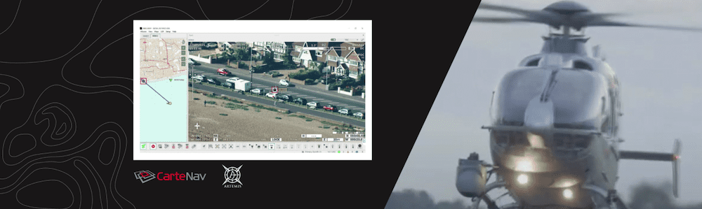
CarteNav has integrated Smith Myers’ ARTEMIS Mobile Phone detection, location and communication sensor with CarteNav’s Advanced Integrated Multi-sensing Surveillance–Intelligence, Surveillance and Reconnaissance (AIMS-ISR) mission software to enable operators to turn every tracked mobile phone into a geo-referenced cellular track. 

Smith Myers’ ARTEMIS range of equipment has been designed to accurately locate mobile telephones in challenging airborne environments. The system is designed to maximize the ability to detect a phone at extended ranges and to provide unique capabilities whilst minimizing crew workload. ARTEMIS is now fully integrated with AIMS-ISR to provide operators with cellular tracks geo-referenced on augmented reality moving maps alongside other equipped sensors such as active EO/IR track following.

“The CarteNav team is thrilled to announce the integration of the ARTEMIS cellular geolocation system with AIMS-ISR alongside Smith Myers. We’ve recently demonstrated the capability with great success, and now we’re excited to officially make it available to current and future AIMS-ISR operators,” said Deirdre Gallant, Vice President of Business Development at CarteNav. “The ARTEMIS capabilities are amazing and integrating that data with AIMS-ISR augmented reality moving maps makes it highly efficient to work with – leading to faster rescues when every second counts.”

“Working with CarteNav continues to be a great experience for everyone at Smith Myers. CarteNav intuitively understood the value in pulling ARTEMIS and AIMS ISR together,” said Andrew Munro, Company Director at Smith Myers. “Witnessing the EO/IR turret automatically lock onto the mobile phone’s location from 20km+ and automatically track the handset on the moving map and live camera feed leaves the viewer in no doubt as to the value of this integration. The bottom line is that this leads to more rapid positive outcomes while reducing operator workload. The results speak for themselves.”

Posted by DA Staff Connect & Contact

Latest Articles

AI-Powered Mission Planning & Target Recognition Software Selected for Long-Range Loitering Munitions

Teledyne FLIR OEM's Prism Supervisor and Prism SKR software is being integrated into Dragoon Technology's UAS under the DIU's Project Artemis

May 22, 2025
GA-ASI Begins Ground Testing of Uncrewed Collaborative Combat Aircraft

GA-ASI has begun ground testing of its YFQ-42A uncrewed jet for the U.S. Air Force’s CCA program, targeting a summer 2025 first flight as part of next-generation combat aviation efforts

May 22, 2025
Support Equipment Solutions for Military Aviation & Aerospace

Defense Advancement showcases WilliamsRDM's support equipment design and manufacturing for military aviation and aerospace programs

May 22, 2025
New Hybrid Solution for Long-Term GNSS-Denied Navigation

Advanced Navigation has demonstrated a major breakthrough with a Hybrid Navigation System designed for GPS-denied environments, combining a strategic-grade FOG INS with a laser velocity sensor

May 21, 2025
New muLTElink Features Improve Command & Control for UAS

uAvionix’s latest muLTElink software update enhances UAS connectivity with automated link management, improving resilience, reliability, and cost-efficiency in complex operations

May 21, 2025
Honeywell Unveils Resilient INS with Anti-Jamming Technology

Honeywell has launched its new HGuide o480 INS, delivering precise, resilient navigation with anti-jamming technology for compact unmanned systems operating in GPS-denied or contested environments

May 21, 2025

Featured Content

New Line of Kinetic-Capable Unmanned Surface Vessels Introduced

Red Cat Holdings enters the maritime autonomy market with a new line of combat-proven USVs, expanding its multi-domain unmanned systems for naval operations

May 20, 2025
Next-Gen Group 2 UAS Enters Production with Extended Endurance & Upgrades

Aurora Flight Sciences upgrades the SKIRON-X Group 2 UAS with greater versatility and tactical mission endurance, as well as announcing the hydrogen-powered SKIRON-XLE variant

May 13, 2025
Discover ANELLO’s SiPhOG™ for GNSS-Denied Navigation at XPO25

CEO of ANELLO Photonics, Dr. Mario Paniccia, will present at Xponential 2025 on the company's SiPhOG-based inertial navigation technology in GPS-denied and GNSS-contested environments.

May 09, 2025
Advancing Defense Capability Through Strategic Collaboration Defense Advancement works with major OEMs to foster collaboration and increase engagement with SMEs, to accelerate innovation and drive defense capabilities forward.