Inertial Explorer Xpress provides the same core processing and utilities as Inertial Explorer along with simplified functions and workflows that have been tailored for UAV markets and small project areas. Data can be post-processed efficiently without compromising position, velocity or attitude accuracy. Inertial Explorer Xpress produces centimetre-level position and attitude solutions compatible with LiDAR, camera and other sensor data.
Differential, Precise Point Positioning (PPP) and Tightly Coupled (TC) processing for GNSS+INS datasets are supported in Inertial Explorer Xpress. This software provides reduced complexity and faster processing time for single base station projects. Inertial Explorer Xpress also verifies and performs quality analysis on your solution with plots that are relevant to your project.
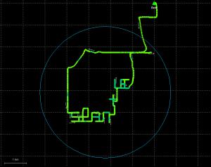
Inertial Explorer Xpress Centroid Circle

The circle encompassing a 3 km radius around the project centroid will be drawn on the map window. Only GNSS+INS processed points within this radius may be exported. The centroid is an average of all non-stationary processed coordinates in the project.


